- View cart You cannot add another "Location of Troops in the Philippine Islands March 31, 1900." to your cart.
- You cannot add "Les Philippines" to the cart because the product is out of stock.
- View cart You cannot add another "Map of the United States showing the Territorial Expansion of a Century 1804 to 1904 insets: 1) The World. 2) Wake Island. 3) Territory of Alaska. 4) Guam Island. 5) Porto Rico. 6) Philippine Islands. 7) Hawaiian Islands. 8) Tutuila, Manua and Smaller Islands of the Samoan Group. 9) Plan of Panama Canal Zone. 10) Plan showing the Thirteen Original States." to your cart.
- You cannot add "Les Philippines" to the cart because the product is out of stock.
View cart “Der stille Ocean und die spanischen Besitzungen im ostindischen Archipel [The Pacific Ocean and the Spanish Colonies in the East Indian Archipelago]” has been added to your cart.
View cart “New York- A Suggestion For the Improvement of the Hudson River Water-front presented before the Architectural League by Milton See Drawn by HM. Pettit from the architect’s plans – [see Page 241]” has been added to your cart.
View cart “1) Plan du port d’ Acapulco sur la Côte du Mexique dans la Mer du Sud. 2) Plan de la Baye de Manille” has been added to your cart.
View cart “The Illustrated London News Vol. 36 – No. 1015” has been added to your cart.
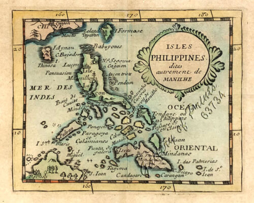
View cart “Isles Philippines dites autrement de Manilhe” has been added to your cart.
View cart “Map of the United States showing the Territorial Expansion of a Century 1804 to 1904 insets: 1) The World. 2) Wake Island. 3) Territory of Alaska. 4) Guam Island. 5) Porto Rico. 6) Philippine Islands. 7) Hawaiian Islands. 8) Tutuila, Manua and Smaller Islands of the Samoan Group. 9) Plan of Panama Canal Zone. 10) Plan showing the Thirteen Original States.” has been added to your cart.
View cart “1. State of the Philippines in 1810; 2. Philippine Progress Prior to 1898” has been added to your cart.
View cart “Chart of the Coast of China and of the Japan Islands including the Marianes and a part of the Philippines. Compiled by order of Commodore M. C. Perry. U.S.N. from the latest authorities with additions and corrections by the U.S. Japan Expedition by Lieuts. W. L. Maury and S. Bent. U.S.N.” has been added to your cart.
View cart “‘Philippines. Philippinen. – Trombe et Typhon. Wasserhose. (Typhoon) [per text: Philippines]” has been added to your cart.
View cart “Die Ostindischen Inseln…” has been added to your cart.
View cart “Cascos de la Laguna, a la voile. [“Cascos” from La Laguna, under Sail]” has been added to your cart.
View cart “Rivière Sagaliud, Golfe de Sandakan” has been added to your cart.
View cart “All Over the Map. A Cartographic Odyssey” has been added to your cart.
View cart “Chart of Port IloIlo and Panay” has been added to your cart.
View cart “Nachrichten von den Pelew-Inseln -in der Westgegend des Stillen Ozeans [An Account of the Pelew Islands, Situated in the Western Part of the Pacific Ocean]” has been added to your cart.
View cart “[Carte Reduite] Carte Réduite des Isles Philippines Pour Servir Aux Vaisseaux du Roy Dressée au Dépost des Cartes Plans et Journaux de la Marine” has been added to your cart.
View cart “City of Manilla” has been added to your cart.