Tel : +63(2)-7729-8168
|
Email Us : gallery@gop.com.ph
My Account
Remember Me
Register
12 Item(s)
-
₱
192,500.00
Great Maps. the world's masterpieces explored and explained
1 x
₱
3,300.00
Sketches from Manilla and Hong-Kong. "Soiree Musicale" at Manilla.
1 x
₱
5,500.00
Dalea Bicolor [Silver Prarie Clover]
1 x
₱
5,500.00
Rivière Sagaliud, Golfe de Sandakan
1 x
₱
3,300.00
Discovering America. Journeys in Search of the New World
1 x
₱
4,400.00
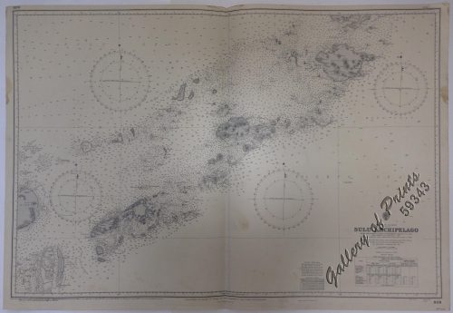
Philippine Islands. Sulu Archipelago. From the United States Government Charts to 1932. With additions and corrections to 1951.
1 x
₱
11,000.00
Übersichtskarte der Franzosischen Expedition in Hinterindien vom Me-khong bis zum Jang-tse-kiang 1867-1868. Mit Benutzung einer Skizze von Garnier … [Map of the French Expedition …based on …Garnier]
1 x
₱
6,600.00
Cascos de la Laguna, a la voile. ["Cascos" from La Laguna, under Sail]
1 x
₱
99,000.00
Philippine Islands. Anchorages in Northern Luzon and the Babuyan Islands. Insets: 1) Babuyan Is. - Fuga I. Musa Bay. From the United States Government Chart to 1931. 2) Babuyan Is. - Camiguin I. Port San Pio Quinto. From the United States Government Chart to 1931. 3) Luzon-North-East Coast Port San Vicente. From the United States Government Chart to 1938. 4) Luzon - East Coast Mauban Anchorage. From the Philippine Government Chart of 1957. 5) Luzon - West Coast. Salomague Harbour and Lapog Bay. From the United States Government Chart of 1934. 6) Luzon - West Coast Port Currimao and Gan Bay. From the United States Government Chart of 1934. 7) Luzon - West Coast Solvec Cove. From the United States Government Chart of 1934. 8) Luzon - West Coast Lingayen Gulf. Port Sual with Cabalitian Bay. From the United States Government Chart of 1922. 9) Luzon - West Coast San Fernando Harbour. From the United States Government Chart of 1936.
1 x
₱
11,000.00
Diez y Seis Años de Regencia (Maria Cristina de Hapsburgo-Lorena) [sic] (1885-1902) [Sixteen Years of Regency of Maria …]
1 x
₱
4,400.00
Antique Maps - Christie's Collectors Guide
1 x
₱
2,500.00
East India Archipelago [Eastern Passages to China and Japan][Chart No.5] London, Published by James Imray and Son, 89 & 89a Minories, 1898
1 x
₱
36,000.00
View Cart
Checkout
Home
About Us
Publications
Shop Online
Framing Services
Exhibits
Picture Hanging System
Contact Us
View cart
“East India Archipelago [Eastern Passages to China and Japan][Chart No.5] London, Published by James Imray and Son, 89 & 89a Minories, 1898” has been added to your cart.
Sort by
Price
Sort by
Default Order
Sort by
Name
Sort by
Price
Sort by
Date
Sort by
Popularity
Show
30 Products
Show
30 Products
Show
60 Products
Show
90 Products
1
2
3
4
…
15
16
17
Next
Shopping Cart
East India Archipelago [Eastern Passages to China and Japan][Chart No.5] London, Published by James Imray and Son, 89 & 89a Minories, 1898
1
Antique Maps - Christie's Collectors Guide
1
Diez y Seis Años de Regencia (Maria Cristina de Hapsburgo-Lorena) [sic] (1885-1902) [Sixteen Years of Regency of Maria …]
1
Philippine Islands. Anchorages in Northern Luzon and the Babuyan Islands. Insets: 1) Babuyan Is. - Fuga I. Musa Bay. From the United States Government Chart to 1931. 2) Babuyan Is. - Camiguin I. Port San Pio Quinto. From the United States Government Chart to 1931. 3) Luzon-North-East Coast Port San Vicente. From the United States Government Chart to 1938. 4) Luzon - East Coast Mauban Anchorage. From the Philippine Government Chart of 1957. 5) Luzon - West Coast. Salomague Harbour and Lapog Bay. From the United States Government Chart of 1934. 6) Luzon - West Coast Port Currimao and Gan Bay. From the United States Government Chart of 1934. 7) Luzon - West Coast Solvec Cove. From the United States Government Chart of 1934. 8) Luzon - West Coast Lingayen Gulf. Port Sual with Cabalitian Bay. From the United States Government Chart of 1922. 9) Luzon - West Coast San Fernando Harbour. From the United States Government Chart of 1936.
1
Cascos de la Laguna, a la voile. ["Cascos" from La Laguna, under Sail]
1
Übersichtskarte der Franzosischen Expedition in Hinterindien vom Me-khong bis zum Jang-tse-kiang 1867-1868. Mit Benutzung einer Skizze von Garnier … [Map of the French Expedition …based on …Garnier]
1
Philippine Islands. Sulu Archipelago. From the United States Government Charts to 1932. With additions and corrections to 1951.
1
Discovering America. Journeys in Search of the New World
1
Rivière Sagaliud, Golfe de Sandakan
1
Dalea Bicolor [Silver Prarie Clover]
1
Sketches from Manilla and Hong-Kong. "Soiree Musicale" at Manilla.
1
Great Maps. the world's masterpieces explored and explained
1
Cart
Checkout
Continue Shopping
12