Tel : +63(2)-7729-8168
|
Email Us : gallery@gop.com.ph
My Account
Remember Me
Register
33 Item(s)
-
₱
1,264,220.00
Manila and the Philippines
1 x
₱
11,000.00
Brains of the Nation. Pedro Paterno, T.H. Pardo de Tavera, Isabelo de los Reyes, and the Production of Modern Knowledge.
1 x
₱
1,200.00
Historia de la Provincia de Philipinas de la Compañia de Jesus. Segunda Parte, que comprehende los progresos de esta Provincia desde el Año de 1616, hasta el de 1716.
1 x
₱
550,000.00
Plan of the Bay of Manilla in the Isle of Luconia, the Principal of the Philippine Islands, Surveyed by Señor Alexandro Malaspina and Communicated By Captn. G.G. Richardson.
1 x
₱
120,000.00
1. Pirogue de peche de la baie de Manille [Fishing canoe from Manila Bay] 2. Plan 3. Elevation de l'arriere [Rear Elevation] 4. Section 5. & 6. Avirons [Oars] 7. Petite pirogue [Small Canoe] 8. Plan 9. Elevation de l'arriere [Rear Elevation]
1 x
₱
50,600.00
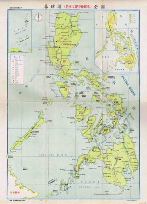
[Full Map of the Philippines] insets: [1. Philippines with Railway Lines] [2. Batan and Babuyan Islands] [All titles in English and Chinese]
1 x
₱
19,800.00
The Murillo Bulletin, Journal of PHIMCOS, Issue No. 15
1 x
₱
790.00
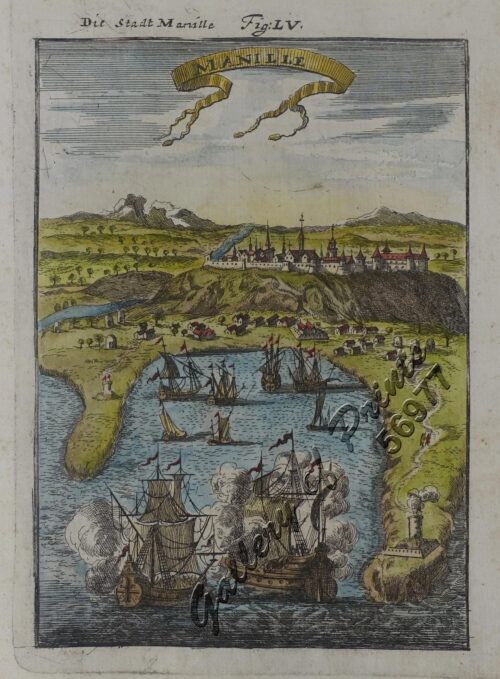
Manille - Die Stadt Manille
1 x
₱
25,500.00
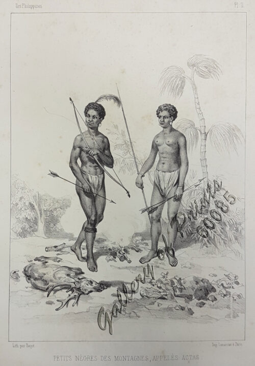
Petits Nègres des Montagnes, Appelés Actas [sic] [Mountain Aborigins called Aetas]
1 x
₱
88,000.00
Philippinen - Exotische Inselwelt La vie exotique des îles Philippines La vita exotica dell'isola Filipina [Philippines - Exotic Island World] 1) [Coconut Trees] 2) [An Old Farmer] 3) [Children Playing with Carabao] 4) [Harvesting Coconut]
1 x
₱
4,400.00
Discovering Antique Maps
1 x
₱
1,500.00
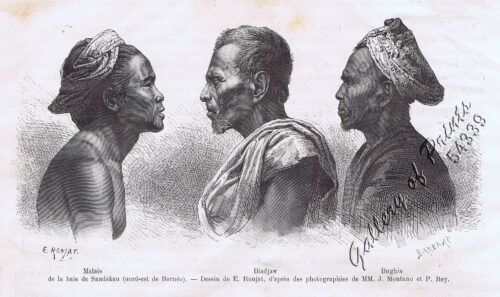
Malais, Bjadjaw, Bughis de la baie de Sandakan
1 x
₱
4,400.00
Bazar de Luçon à Manille, après le tremblement de terre. [Luzon Bazaar in Manila, after the Earthquake.]
1 x
₱
4,400.00
The Philippine Islands
1 x
₱
7,700.00
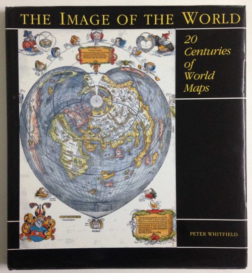
The Image of the World. 20 Centuries of World Maps
1 x
₱
3,300.00
Ladmiral surmonte s'en allant au fond a nostre veúe
1 x
₱
49,600.00
Harper's Weekly - A Journal of Civilization with frontispiece: The End of the Coast. - Drawn by A. B. Frost.
1 x
₱
17,600.00
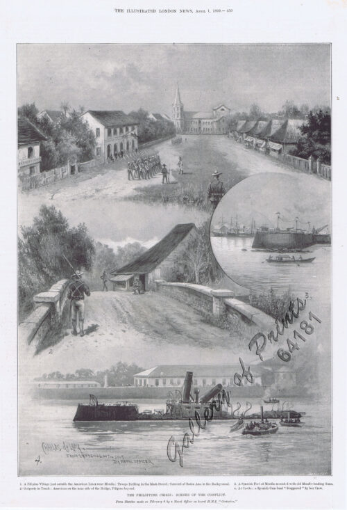
The Philippine Crisis: Scenes of the Conflict. 1. A Filipino Village just outside the American Lines near Manila; 2. Outposts in Touch: American on the near side of the Bridge, Filipino beyond; 3. A Spanish Fort at Manila mounted with old Muzzle-loading Guns; 4. At Cavite: a Spanish Gun-boat “Scuppered” by her Crew.
1 x
₱
6,600.00
1) Merops Bicolor [Rufous-crowned Bee-eater]; 2) Merops Sumatranus [Blue-throated Bee-eater]
1 x
₱
14,960.00
Bibliography of the Philippine Islands. Printed and Manuscript. Preceded by a Descriptive Account of the most important Archives and Collections containing Philippina
1 x
₱
4,400.00
The Operations Before Manila - A Daring Reconnoissance by Three American Officers. 1. Lieut. Means, U.S.V., 1st Colorado Infantry 2. Major J.F. Bell. U.S.V.E., (Lieut. 7th U.S. Cavalry) 3.Lieut. Clotworthy, U.S.V., 1st Colorado Infantry 4. Reconnoitring Spanish Fort from Behind Obstacles. ( Distance, 150 Yards) 5. Reconnoitring Spanish Fort from Behind Obstacles. ( Distance, 137 Yards) 6. Reconnoitring Right Flank of Spanish Fort by Swimming 7. Reconnoitring Spanish Trenches from Outpost. (Distance, 300 yards)
1 x
₱
4,400.00
Isla de Paragua o Palawan Sur pl. 25 (Southern Palawan)
1 x
₱
6,600.00
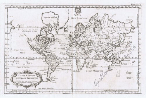
Carte Reduite du Globe Terrestre
1 x
₱
55,900.00
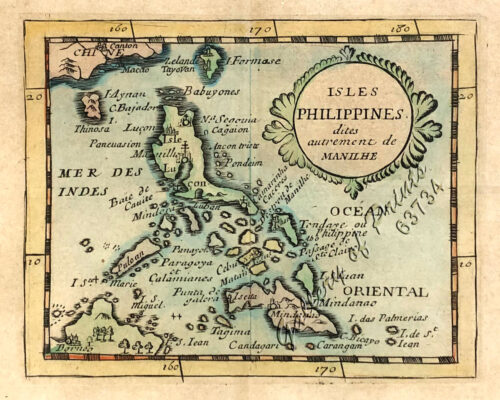
Isles Philippines dites autrement de Manilhe
1 x
₱
49,500.00
The Murillo Bulletin, Journal of PHIMCOS, Issue No. 8
1 x
₱
570.00
Itinéraire de l'ascension de l'Apó;… {Itinerary of the Mount Apo Conquest]
1 x
₱
6,600.00
Océanique: Isles du Scarborough. 'pl. 16 Note sur le nouv. Hollande. Pour le commencement voyez la carte no. 29 ... Pour la suite voyez la carte no. 17. [Notes on New Holland. For the beginning please go to map no. 29….For the continuation please see map no. 17]
1 x
₱
8,800.00
Mosque in the Town of Sooloo
1 x
₱
13,200.00
Mittheilungen aus Justus Perthes' Geographischer Anstalt. über wichtige neue Erforschungen auf dem Gesammtgebiete der Geographie von Dr. A. Petermann. - Ergänzungsband VI, 1869-71 Inhalt:[Supplement Vol. 6 contents] No. 26. Lindemann, die arktische Fischerei der Deutschen Seestädte 1620-1868 No. 27. Payer, die südlichen Ortler-Alpen No. 28. Koldewey und Petermann, die erste Deutsche Nordpolar-Expedition, 1868 No. 29. Petermann, Australien in 1871. Mit geograph.- statistischem Compendium von Meinicke
1 x
₱
8,600.00
Carayas ou machines a pecher et Banka de Manille. ["Tarayas" (correctly called "Salambas") or fishing contraptions; and "Banka" from Manila]
1 x
₱
99,000.00
The Illustrated London News Vol. 36 - No. 1015
1 x
₱
6,600.00
Brachyurus Steerii, ad. et jur. (Steere's Pitta)
1 x
₱
11,000.00
Cycas Circinalis [Sage Palm Tree]
1 x
₱
7,700.00
View Cart
Checkout
Home
About Us
Publications
Shop Online
Framing Services
Exhibits
Picture Hanging System
Contact Us
View Cart
You cannot add that amount to the cart — we have 1 in stock and you already have 1 in your cart.
Sort by
Name
Sort by
Default Order
Sort by
Name
Sort by
Price
Sort by
Date
Sort by
Popularity
Show
30 Products
Show
30 Products
Show
60 Products
Show
90 Products
‘Luzon, West Coast – Port Santo Tomas – Li...
₱
2,200.00
Add to cart
Details
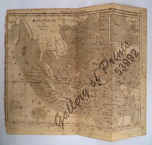
‘Malaisie. inset: I. Bassilan
₱
4,400.00
Add to cart
Details
‘XIV. Von Schanghai nach Guaham und Puynipet. [Carolin...
₱
3,300.00
Add to cart
Details
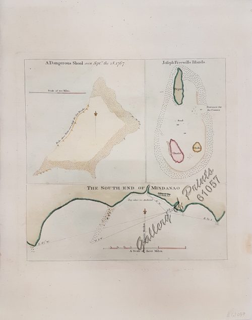
1) A Dangerous Shoal… 2) Joseph Freewills Island. 3) The S...
₱
13,500.00
Add to cart
Details
1) Carta dell’Isole Filippine [1st sheet]. 2) Carta de...
₱
61,600.00
Add to cart
Details
1) Carte des Isles Philippines (1e feuille) Kaart der Philip...
₱
77,000.00
Add to cart
Details
1) Isla de Paragua o Palawan Sur pl. 25 (Southern Palawan)
₱
7,700.00
Add to cart
Details
1) Islas Filipinas 1ª Hoja; 2) Islas Filipinas 2...
₱
39,600.00
Add to cart
Details
1) Islas Filipinas: Primera Hoja Central; 2) Islas Filipinas...
₱
99,000.00
Add to cart
Details
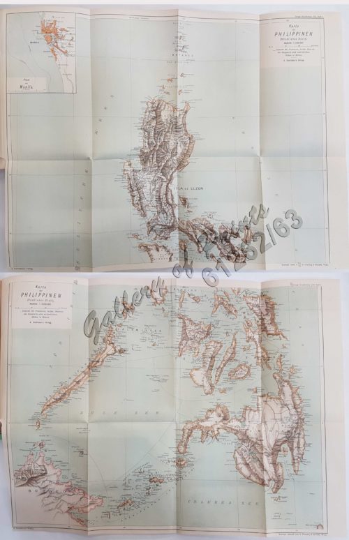
1) Karte der Philippinen (Nördliches Blatt), inset: Plan vo...
₱
39,600.00
Add to cart
Details
1) Mapa de las Islas Filipinas 2) Islas Carolinas 3) Islas...
₱
15,700.00
Add to cart
Details
1) Plan du port d’ Acapulco sur la Côte du Mexique da...
₱
26,400.00
Add to cart
Details
1) Plan of Solsogon Harbour on the South Coast of Luconia. 2...
₱
36,500.00
Add to cart
Details
1. Borneo. 2. The Philippine Islands.
₱
15,400.00
Add to cart
Details
1. Cap Blanc sur la Cote des Patagons,… Kaap Blanco aan de...
₱
4,400.00
Add to cart
Details
A Chart of the Channel in the Philipine Islands [sic] Throug...
₱
26,400.00
Add to cart
Details
A Chart of the Channel in the Phillippine Islands through wh...
₱
44,000.00
Add to cart
Details
A Chart of the Channel in the Phillippine [sic] Islands thro...
₱
39,600.00
Add to cart
Details
A Chart of the China Sea, and Philippine Islands, with the A...
₱
780,000.00
Add to cart
Details
A Chart of the Coast of China from Cambodia to Nanquam with ...
₱
155,000.00
Add to cart
Details
A Chart of the Pacific Ocean from the Equinoctial to the Lat...
₱
15,400.00
Add to cart
Details
A Chart of the Pelew Islands…
₱
39,600.00
Add to cart
Details
A Map of the East Indies from the latest Authorities and Obs...
₱
26,400.00
Add to cart
Details
A New and Accurate Map of the East India Islands
₱
56,100.00
Add to cart
Details
A New Map of the East Indies, Taken from Mr. de Fer’s ...
₱
49,500.00
Add to cart
Details
A New Map of the Philippine Islands, Drawn from the best Aut...
₱
49,500.00
Add to cart
Details
1
2
3
4
…
15
16
17
Next
Shopping Cart
Cycas Circinalis [Sage Palm Tree]
1
Brachyurus Steerii, ad. et jur. (Steere's Pitta)
1
The Illustrated London News Vol. 36 - No. 1015
1
Carayas ou machines a pecher et Banka de Manille. ["Tarayas" (correctly called "Salambas") or fishing contraptions; and "Banka" from Manila]
1
Mittheilungen aus Justus Perthes' Geographischer Anstalt. über wichtige neue Erforschungen auf dem Gesammtgebiete der Geographie von Dr. A. Petermann. - Ergänzungsband VI, 1869-71 Inhalt:[Supplement Vol. 6 contents] No. 26. Lindemann, die arktische Fischerei der Deutschen Seestädte 1620-1868 No. 27. Payer, die südlichen Ortler-Alpen No. 28. Koldewey und Petermann, die erste Deutsche Nordpolar-Expedition, 1868 No. 29. Petermann, Australien in 1871. Mit geograph.- statistischem Compendium von Meinicke
1
Mosque in the Town of Sooloo
1
Océanique: Isles du Scarborough. 'pl. 16 Note sur le nouv. Hollande. Pour le commencement voyez la carte no. 29 ... Pour la suite voyez la carte no. 17. [Notes on New Holland. For the beginning please go to map no. 29….For the continuation please see map no. 17]
1
Itinéraire de l'ascension de l'Apó;… {Itinerary of the Mount Apo Conquest]
1
The Murillo Bulletin, Journal of PHIMCOS, Issue No. 8
1
Isles Philippines dites autrement de Manilhe
1
Carte Reduite du Globe Terrestre
1
Isla de Paragua o Palawan Sur pl. 25 (Southern Palawan)
1
The Operations Before Manila - A Daring Reconnoissance by Three American Officers. 1. Lieut. Means, U.S.V., 1st Colorado Infantry 2. Major J.F. Bell. U.S.V.E., (Lieut. 7th U.S. Cavalry) 3.Lieut. Clotworthy, U.S.V., 1st Colorado Infantry 4. Reconnoitring Spanish Fort from Behind Obstacles. ( Distance, 150 Yards) 5. Reconnoitring Spanish Fort from Behind Obstacles. ( Distance, 137 Yards) 6. Reconnoitring Right Flank of Spanish Fort by Swimming 7. Reconnoitring Spanish Trenches from Outpost. (Distance, 300 yards)
1
Bibliography of the Philippine Islands. Printed and Manuscript. Preceded by a Descriptive Account of the most important Archives and Collections containing Philippina
1
1) Merops Bicolor [Rufous-crowned Bee-eater]; 2) Merops Sumatranus [Blue-throated Bee-eater]
1
The Philippine Crisis: Scenes of the Conflict. 1. A Filipino Village just outside the American Lines near Manila; 2. Outposts in Touch: American on the near side of the Bridge, Filipino beyond; 3. A Spanish Fort at Manila mounted with old Muzzle-loading Guns; 4. At Cavite: a Spanish Gun-boat “Scuppered” by her Crew.
1
Harper's Weekly - A Journal of Civilization with frontispiece: The End of the Coast. - Drawn by A. B. Frost.
1
Ladmiral surmonte s'en allant au fond a nostre veúe
1
The Image of the World. 20 Centuries of World Maps
1
The Philippine Islands
1
Bazar de Luçon à Manille, après le tremblement de terre. [Luzon Bazaar in Manila, after the Earthquake.]
1
Malais, Bjadjaw, Bughis de la baie de Sandakan
1
Discovering Antique Maps
1
Philippinen - Exotische Inselwelt La vie exotique des îles Philippines La vita exotica dell'isola Filipina [Philippines - Exotic Island World] 1) [Coconut Trees] 2) [An Old Farmer] 3) [Children Playing with Carabao] 4) [Harvesting Coconut]
1
Petits Nègres des Montagnes, Appelés Actas [sic] [Mountain Aborigins called Aetas]
1
Manille - Die Stadt Manille
1
The Murillo Bulletin, Journal of PHIMCOS, Issue No. 15
1
[Full Map of the Philippines] insets: [1. Philippines with Railway Lines] [2. Batan and Babuyan Islands] [All titles in English and Chinese]
1
1. Pirogue de peche de la baie de Manille [Fishing canoe from Manila Bay] 2. Plan 3. Elevation de l'arriere [Rear Elevation] 4. Section 5. & 6. Avirons [Oars] 7. Petite pirogue [Small Canoe] 8. Plan 9. Elevation de l'arriere [Rear Elevation]
1
Plan of the Bay of Manilla in the Isle of Luconia, the Principal of the Philippine Islands, Surveyed by Señor Alexandro Malaspina and Communicated By Captn. G.G. Richardson.
1
Historia de la Provincia de Philipinas de la Compañia de Jesus. Segunda Parte, que comprehende los progresos de esta Provincia desde el Año de 1616, hasta el de 1716.
1
Brains of the Nation. Pedro Paterno, T.H. Pardo de Tavera, Isabelo de los Reyes, and the Production of Modern Knowledge.
1
Manila and the Philippines
1
Cart
Checkout
Continue Shopping
33