Tel : +63(2)-7729-8168
|
Email Us : gallery@gop.com.ph
My Account
Remember Me
Register
19 Item(s)
-
₱
705,000.00
The Revolt in the Philippine Islands. 1. Philippine Aborigines. 2. View of the River Pasig at Manila. 3. Gate Leading Within the Walls. 4. Village of San Juento. 5. Types of the Native Soldiery.
1 x
₱
5,500.00
Dr. A. Petermann's Mittheilungen aus Justus Perthes' Geographischer Anstalt. Herausgegeben von Prof. Dr. A. Supan. - Ergänzungsband XVIII, 1886-1887 Inhalt: [Supplement Vol. 18 contents] No. 81. Bayberger, Geographisch-geologische Studien aus dem Böhmerwalde. No. 82. v. Schlagintweit, Die Pacifischen Eisenbahnen in Nordamerika. No. 83. Berndt, Der Alpenföhn in seinem Einflufs auf Natur- und Menschenleben. No. 84. Supan, Archiv für Wirtschaftsgeographie. I. Nordamerika, 1880-1885. No. 85. Radde, Aus den Dagestanischen Hochalpen.
1 x
₱
6,000.00
The Engagement of the CENTURION and ACAPULCO, off Cape Espiritu-Santo in which the latter was taken
1 x
₱
18,700.00
Manila Harbor Complimentary Map of the City of Manila.
1 x
₱
22,000.00
Amarantus Tricolor. L. [English: Joseph's Coat] [Belongs to the Kolitis Family]
1 x
₱
26,400.00
1) Isla de Paragua o Palawan Sur pl. 25 (Southern Palawan)
1 x
₱
7,700.00
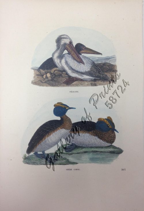
1) Pélicans. 2) Grèbe Cornu.
1 x
₱
5,500.00
1. Casco, bateau de transport de Manille ["Casco", cargo boat from Manila] 2. Plan 3. Elevation de l'arriere [Rear Elevation] 4. Section 5. Pirogue a double balancier de la Laguna [Double Outrigger Canoe from La Laguna] 6. Plan 7. Section
1 x
₱
49,600.00
1) Islas Filipinas: Primera Hoja Central; 2) Islas Filipinas: Segunda Hoja Central; 3) Posesiones de Ultramar (Oceania) - Islas Filipinas
1 x
₱
99,000.00
East India Archipelago [Eastern Passages to China and Japan][Chart No.5] London, Published by James Imray and Son, 89 & 89a Minories, 1898
1 x
₱
36,000.00
1. Pirogue de peche de la baie de Manille [Fishing canoe from Manila Bay] 2. Plan 3. Elevation de l'arriere [Rear Elevation] 4. Section 5. & 6. Avirons [Oars] 7. Petite pirogue [Small Canoe] 8. Plan 9. Elevation de l'arriere [Rear Elevation]
1 x
₱
50,600.00
Alegoria de los Santos Reyes (pág. 30.) [Three Kings]
1 x
₱
6,600.00
The Philippines in Ancient Chinese Maps
1 x
₱
2,400.00
El Indicador del Viajero en las Islas Filipinas
1 x
₱
77,000.00
Twenty Years in the Philippine Islands: [A critical review with excerpts from the work of P. de la Gironiere. A rare original article from the Blackwood's Edinburgh Magazine.]
1 x
₱
6,600.00
Filipinas. Distrito de Lepanto Description general accompañada de itinerario y croquis del territorio,…
1 x
₱
99,000.00
Sammlung gemeinverständlicher wissenschaftlicher Vorträge [Collection of Scientific Presentations in a Generally Comprehensible Version] [INCLUDING:] Die Philippinen. Eine übersichtliche Darstellung der ethnographischen und historisch=politischen Verhältnisse des Archipels. [An Overview of the Ethnographic and Historical-Political Situation in the Archipelago] Mit einem Anhange - Die wichtigsten Paragraphen der Verfassung der philippinischen Republik. [The most important paragraphs of the Constitution of the Philippine Republic]
1 x
₱
15,700.00
1) Mapa de las Islas Filipinas 2) Islas Carolinas 3) Islas Marianas ó de los Ladrones
1 x
₱
15,700.00
A Chart of the Coast of China from Cambodia to Nanquam with part of Japan.
1 x
₱
155,000.00
View Cart
Checkout
Home
About Us
Publications
Shop Online
Framing Services
Exhibits
Picture Hanging System
Contact Us
View cart
“A Chart of the Coast of China from Cambodia to Nanquam with part of Japan.” has been added to your cart.
Sort by
Name
Sort by
Default Order
Sort by
Name
Sort by
Price
Sort by
Date
Sort by
Popularity
Show
30 Products
Show
30 Products
Show
60 Products
Show
90 Products
‘Luzon, West Coast – Port Santo Tomas – Li...
₱
2,200.00
Add to cart
Details
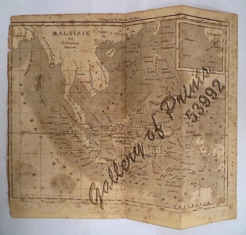
‘Malaisie. inset: I. Bassilan
₱
4,400.00
Add to cart
Details
‘XIV. Von Schanghai nach Guaham und Puynipet. [Carolin...
₱
3,300.00
Add to cart
Details
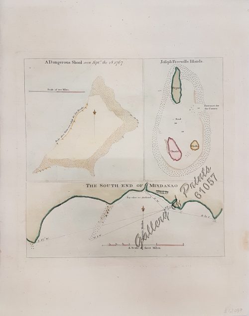
1) A Dangerous Shoal… 2) Joseph Freewills Island. 3) The S...
₱
13,500.00
Add to cart
Details
1) Carta dell’Isole Filippine [1st sheet]. 2) Carta de...
₱
61,600.00
Add to cart
Details
1) Carte des Isles Philippines (1e feuille) Kaart der Philip...
₱
77,000.00
Add to cart
Details
1) Isla de Paragua o Palawan Sur pl. 25 (Southern Palawan)
₱
7,700.00
Add to cart
Details
1) Islas Filipinas 1ª Hoja; 2) Islas Filipinas 2...
₱
39,600.00
Add to cart
Details
1) Islas Filipinas: Primera Hoja Central; 2) Islas Filipinas...
₱
99,000.00
Add to cart
Details
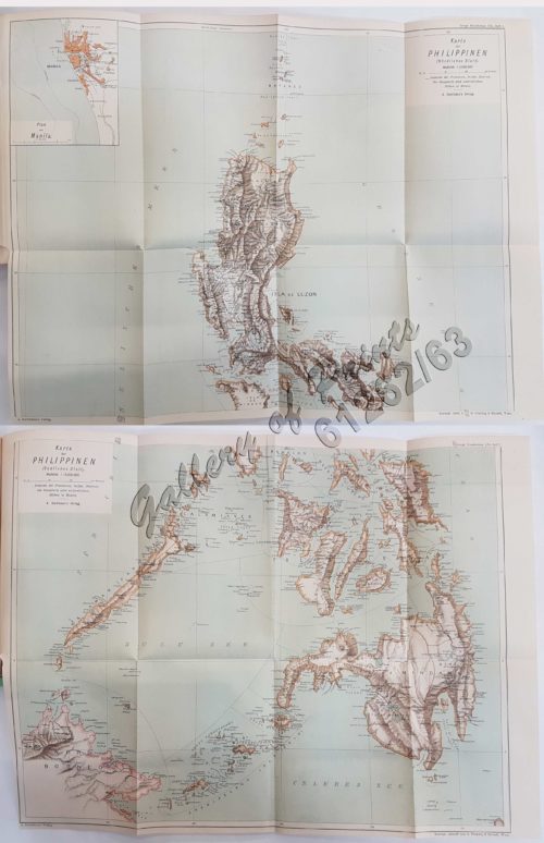
1) Karte der Philippinen (Nördliches Blatt), inset: Plan vo...
₱
39,600.00
Add to cart
Details
1) Mapa de las Islas Filipinas 2) Islas Carolinas 3) Islas...
₱
15,700.00
Add to cart
Details
1) Plan du port d’ Acapulco sur la Côte du Mexique da...
₱
26,400.00
Add to cart
Details
1) Plan of Solsogon Harbour on the South Coast of Luconia. 2...
₱
36,500.00
Add to cart
Details
1. Borneo. 2. The Philippine Islands.
₱
15,400.00
Add to cart
Details
1. Cap Blanc sur la Cote des Patagons,… Kaap Blanco aan de...
₱
4,400.00
Add to cart
Details
A Chart of the Channel in the Philipine Islands [sic] Throug...
₱
26,400.00
Add to cart
Details
A Chart of the Channel in the Phillippine Islands through wh...
₱
44,000.00
Add to cart
Details
A Chart of the Channel in the Phillippine [sic] Islands thro...
₱
39,600.00
Add to cart
Details
A Chart of the China Sea, and Philippine Islands, with the A...
₱
780,000.00
Add to cart
Details
A Chart of the Coast of China from Cambodia to Nanquam with ...
₱
155,000.00
Add to cart
Details
A Chart of the Pacific Ocean from the Equinoctial to the Lat...
₱
15,400.00
Add to cart
Details
A Chart of the Pelew Islands…
₱
39,600.00
Add to cart
Details
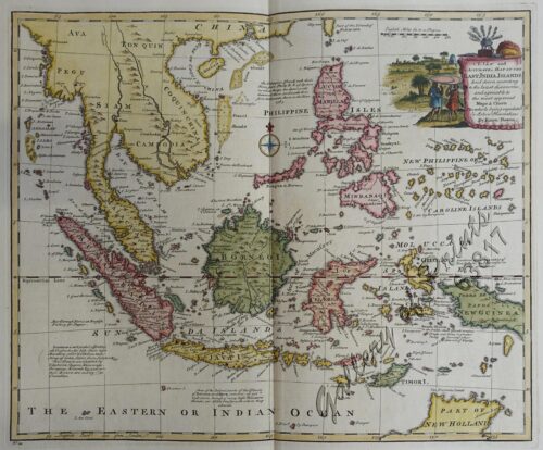
A Map of the East Indies from the latest Authorities and Obs...
₱
26,400.00
Add to cart
Details
A New and Accurate Map of the East India Islands
₱
56,100.00
Add to cart
Details
A New Map of the East Indies, Taken from Mr. de Fer’s ...
₱
49,500.00
Add to cart
Details
A New Map of the Philippine Islands, Drawn from the best Aut...
₱
49,500.00
Add to cart
Details
1
2
3
4
…
15
16
17
Next
Shopping Cart
A Chart of the Coast of China from Cambodia to Nanquam with part of Japan.
1
1) Mapa de las Islas Filipinas 2) Islas Carolinas 3) Islas Marianas ó de los Ladrones
1
Sammlung gemeinverständlicher wissenschaftlicher Vorträge [Collection of Scientific Presentations in a Generally Comprehensible Version] [INCLUDING:] Die Philippinen. Eine übersichtliche Darstellung der ethnographischen und historisch=politischen Verhältnisse des Archipels. [An Overview of the Ethnographic and Historical-Political Situation in the Archipelago] Mit einem Anhange - Die wichtigsten Paragraphen der Verfassung der philippinischen Republik. [The most important paragraphs of the Constitution of the Philippine Republic]
1
Filipinas. Distrito de Lepanto Description general accompañada de itinerario y croquis del territorio,…
1
Twenty Years in the Philippine Islands: [A critical review with excerpts from the work of P. de la Gironiere. A rare original article from the Blackwood's Edinburgh Magazine.]
1
El Indicador del Viajero en las Islas Filipinas
1
The Philippines in Ancient Chinese Maps
1
Alegoria de los Santos Reyes (pág. 30.) [Three Kings]
1
1. Pirogue de peche de la baie de Manille [Fishing canoe from Manila Bay] 2. Plan 3. Elevation de l'arriere [Rear Elevation] 4. Section 5. & 6. Avirons [Oars] 7. Petite pirogue [Small Canoe] 8. Plan 9. Elevation de l'arriere [Rear Elevation]
1
East India Archipelago [Eastern Passages to China and Japan][Chart No.5] London, Published by James Imray and Son, 89 & 89a Minories, 1898
1
1) Islas Filipinas: Primera Hoja Central; 2) Islas Filipinas: Segunda Hoja Central; 3) Posesiones de Ultramar (Oceania) - Islas Filipinas
1
1. Casco, bateau de transport de Manille ["Casco", cargo boat from Manila] 2. Plan 3. Elevation de l'arriere [Rear Elevation] 4. Section 5. Pirogue a double balancier de la Laguna [Double Outrigger Canoe from La Laguna] 6. Plan 7. Section
1
1) Pélicans. 2) Grèbe Cornu.
1
1) Isla de Paragua o Palawan Sur pl. 25 (Southern Palawan)
1
Amarantus Tricolor. L. [English: Joseph's Coat] [Belongs to the Kolitis Family]
1
Manila Harbor Complimentary Map of the City of Manila.
1
The Engagement of the CENTURION and ACAPULCO, off Cape Espiritu-Santo in which the latter was taken
1
Dr. A. Petermann's Mittheilungen aus Justus Perthes' Geographischer Anstalt. Herausgegeben von Prof. Dr. A. Supan. - Ergänzungsband XVIII, 1886-1887 Inhalt: [Supplement Vol. 18 contents] No. 81. Bayberger, Geographisch-geologische Studien aus dem Böhmerwalde. No. 82. v. Schlagintweit, Die Pacifischen Eisenbahnen in Nordamerika. No. 83. Berndt, Der Alpenföhn in seinem Einflufs auf Natur- und Menschenleben. No. 84. Supan, Archiv für Wirtschaftsgeographie. I. Nordamerika, 1880-1885. No. 85. Radde, Aus den Dagestanischen Hochalpen.
1
The Revolt in the Philippine Islands. 1. Philippine Aborigines. 2. View of the River Pasig at Manila. 3. Gate Leading Within the Walls. 4. Village of San Juento. 5. Types of the Native Soldiery.
1
Cart
Checkout
Continue Shopping
19