Tel : +63(2)-7729-8168
|
Email Us : gallery@gop.com.ph
My Account
Remember Me
Register
45 Item(s)
-
₱
4,491,100.00
The Varieties of Human Greatness. A Discourse on the Life and Character of the Hon. Nathaniel Bowditch LL.D. F.R.S. delivered in the Church on Church Green, March 25, 1838
1 x
₱
11,000.00
[Sailing Boat] Starlined canvas(?) [untitled]
1 x
₱
5,500.00
Pont de Manille [Manila Bridge]
1 x
₱
49,500.00
Isla de Luzon pl. 10, inset: Pto. de Banacalan [Marinduque] (Quezon [or Tayabas], Camarines Norte, Marinduque, Balegin [Balesin], Calbalete [Cagbalete]… )
1 x
₱
6,600.00
Mapping the World: Maps and Their History
1 x
₱
5,500.00
Mapa de Filipinas, Joló y norte de Borneo
1 x
₱
7,700.00
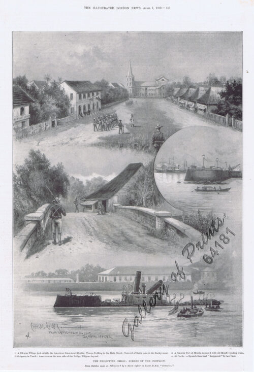
The Philippine Crisis: Scenes of the Conflict. 1. A Filipino Village just outside the American Lines near Manila; 2. Outposts in Touch: American on the near side of the Bridge, Filipino beyond; 3. A Spanish Fort at Manila mounted with old Muzzle-loading Guns; 4. At Cavite: a Spanish Gun-boat “Scuppered” by her Crew.
1 x
₱
6,600.00
Puerto de Surigao
1 x
₱
3,300.00
Campagnard Tagal, pres de Manille (Iles Philippines.) [Tagalog Man from the Countryside near Manila]
1 x
₱
290,000.00
Palais du Sultan de Soulou… [Palace of the Sultan of Sulu]
1 x
₱
13,200.00
Environs of Manila
1 x
₱
11,000.00
[Carte Reduite] Carte Réduite des Isles Philippines Pour Servir Aux Vaisseaux du Roy Dressée au Dépost des Cartes Plans et Journaux de la Marine
1 x
₱
425,000.00
Zeocephus Cinnamomeus (Fig. 1) [Rufous Paradise Flycatcher] Z. Cyanescens (Fig. 2), pl.48 [Blue Paradise Flycatcher]
1 x
₱
22,000.00
1. Panguingui (Card-playing) in Manilla; 2. Planting Rice in Manilla.
1 x
₱
7,700.00
Carte des Iles Philippines Pour servirà l'intelligence de l'ouvrage sur les Possessions Espagnoles dans l'Océanie, par Mr. J. Mallat. inset: Iles Batanes
1 x
₱
980,000.00
Mittheilungen aus Justus Perthes' Geographischer Anstalt. über wichtige neue Erforschungen auf dem Gesammtgebiete der Geographie von Dr. A. Petermann. - Ergänzungsband VIII, 1873-74 Inhalt: [Supplement Vol. 8 contents] No. 35. Behm und Wagner, die Bevölkerung der Erde, II. No. 36. Dr. G. Radde, vier Vorträge über den Kaukasus. No. 37. Carl Mauch's Reisen im Innern von Süd-Afrika, 1865-72. No. 38. A. Wojeikof, die atmosphärische Circulation. Verbreitung des Luftdruckes, der Winde und der Regen auf der Oberfläche der Erde.
1 x
₱
6,000.00
Chart of the Coast of China and of the Japan Islands including the Marianes and a part of the Philippines. Compiled by order of Commodore M. C. Perry. U.S.N. from the latest authorities with additions and corrections by the U.S. Japan Expedition by Lieuts. W. L. Maury and S. Bent. U.S.N.
1 x
₱
39,600.00
Insulae Philippinae… [inset: Manila]
1 x
₱
1,250,000.00
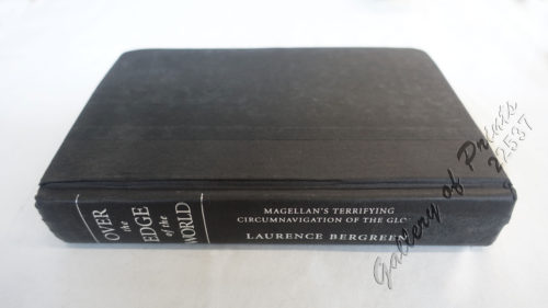
Over the Edge of the World Magellan's Terrifying Circumnavigation of the Globe
1 x
₱
4,400.00
Islas de Romblón, Tablas y Sibuyán pl. 16, inset: Isla Alad, I. Lugbung
1 x
₱
6,600.00
Der Vulkan von Taal auf Luzon
1 x
₱
7,700.00
Handbook of the Philippine Islands
1 x
₱
13,200.00
Mapa General Atlas Geografico Descriptivo de la Peninsula Ibérica Yslas Baleares, Canarias y posesiones Españolas de Ultramar por el Comandte Capn de Infa auxiliar que ha sido del Deposito de la Guerra D. Emilio Valverde Y Alvarez. [insets]: 1. Islas Filipinas 2. Posesiones Españolas de golfo del Guinea 3. Antillas Españolas 4. Islas Canarias
1 x
₱
17,700.00
Die Länder Asie nach ihrer gelegenheit… [The Countries of Asia as Situated till….]
1 x
₱
88,000.00
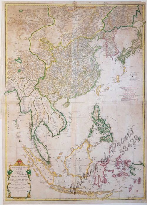
Seconde partie de la Carte d'Asie contenant la Chine et partie de la Tartarie, l'Inde au delà du Gange, les Isles Sumatra, Java, Borneo, Moluques, Philippines, et du Japon.
1 x
₱
39,600.00
Manila Harbor Complimentary Map of the City of Manila.
1 x
₱
22,000.00
Bahia de Manila
1 x
₱
46,200.00
Early Mapping of Southeast Asia
1 x
₱
9,600.00
Fifty Shades of Philippine Art: Damián Domingo
1 x
₱
1,500.00
Die Ostindischen Inseln...
1 x
₱
39,600.00
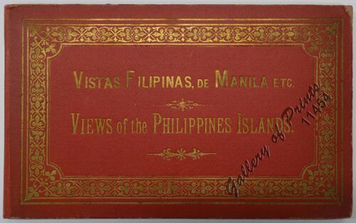
Vistas Filipinas, de Manila etc. Views of the Philippine Islands
1 x
₱
9,900.00
Courtiers and Cannibals, Angels and Amazons. The Art of the Decorative Cartographic Titlepage.
1 x
₱
5,500.00
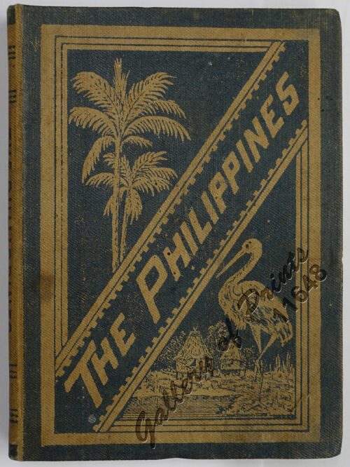
The Philippine Islands
1 x
₱
7,700.00
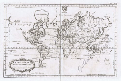
Carte Reduite du Globe Terrestre
1 x
₱
55,900.00
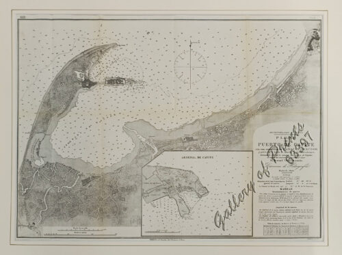
Archipiélago Filipino. Plano del Puerto de Cavite con sus ensenadas de Cañacao y Bacoor y parte de la bahia de Manila hasta Parañaque, levantado en 1872 por la comision hidrográfica de Filipinas al mando del teniente de Navio de 1a. clase [inset:] Arsenal de Cavite
1 x
₱
9,900.00
Adventures and Encounters – Europeans in Southeast Asia With a Foreword by Victor T. King
1 x
₱
2,900.00
Sea Monsters on Medieval and Renaissance Maps
1 x
₱
2,200.00
Harper's Weekly - A Journal of Civilization with frontispiece: Ice-Yachting-Hard-A-Lee! Drawn by W. P. Snyder.
1 x
₱
7,700.00
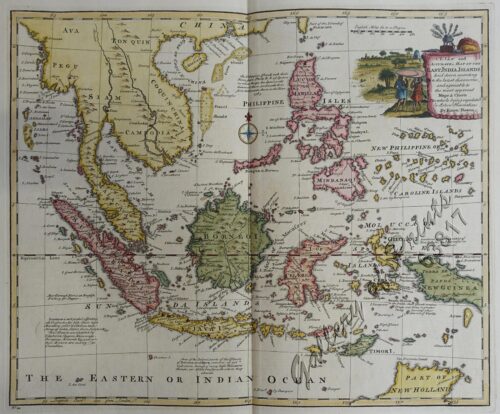
East India Isles
1 x
₱
18,700.00
Cycas Circinalis [Sage Palm Tree]
1 x
₱
7,700.00
Chart of Port IloIlo and Panay
1 x
₱
4,400.00
Itinéraire de l'ascension de l'Apó;… {Itinerary of the Mount Apo Conquest]
1 x
₱
6,600.00
Ueber die Negritos der Philippinen. [Regarding the Negritos of the Philippines]
1 x
₱
15,700.00
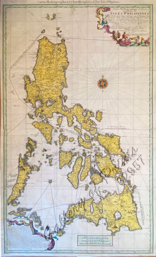
Carte Hydrographique & Chorographique des Isles Philippines (Carta Hydrographica y Chorographica de las Ysles Filipinas)
1 x
₱
425,000.00
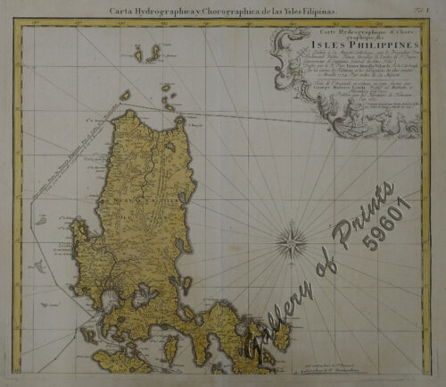
Carte Hydrographique & Chorographique des Isles Philippines (Carta Hydrographica y Chorographica de las Ysles Filipinas)
1 x
₱
475,000.00
View Cart
Checkout
Home
About Us
Publications
Shop Online
Framing Services
Exhibits
Picture Hanging System
Contact Us
View cart
“Carte Hydrographique & Chorographique des Isles Philippines (Carta Hydrographica y Chorographica de las Ysles Filipinas)” has been added to your cart.
Sort by
Name
Sort by
Default Order
Sort by
Name
Sort by
Price
Sort by
Date
Sort by
Popularity
Show
30 Products
Show
30 Products
Show
60 Products
Show
90 Products
‘Luzon, West Coast – Port Santo Tomas – Li...
₱
2,200.00
Add to cart
Details
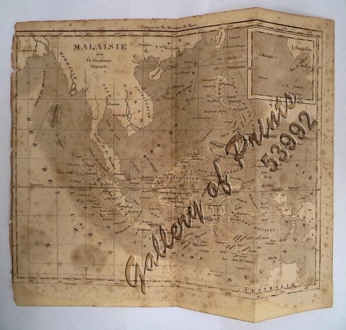
‘Malaisie. inset: I. Bassilan
₱
4,400.00
Add to cart
Details
‘XIV. Von Schanghai nach Guaham und Puynipet. [Carolin...
₱
3,300.00
Add to cart
Details
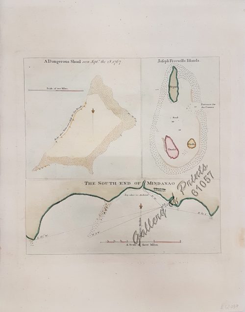
1) A Dangerous Shoal… 2) Joseph Freewills Island. 3) The S...
₱
13,500.00
Add to cart
Details
1) Carta dell’Isole Filippine [1st sheet]. 2) Carta de...
₱
61,600.00
Add to cart
Details
1) Carte des Isles Philippines (1e feuille) Kaart der Philip...
₱
77,000.00
Add to cart
Details
1) Isla de Paragua o Palawan Sur pl. 25 (Southern Palawan)
₱
7,700.00
Add to cart
Details
1) Islas Filipinas 1ª Hoja; 2) Islas Filipinas 2...
₱
39,600.00
Add to cart
Details
1) Islas Filipinas: Primera Hoja Central; 2) Islas Filipinas...
₱
99,000.00
Add to cart
Details
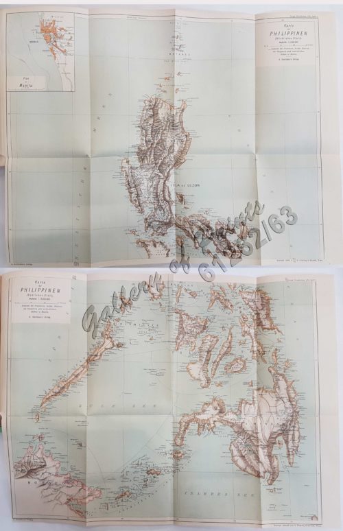
1) Karte der Philippinen (Nördliches Blatt), inset: Plan vo...
₱
39,600.00
Add to cart
Details
1) Mapa de las Islas Filipinas 2) Islas Carolinas 3) Islas...
₱
15,700.00
Add to cart
Details
1) Plan du port d’ Acapulco sur la Côte du Mexique da...
₱
26,400.00
Add to cart
Details
1) Plan of Solsogon Harbour on the South Coast of Luconia. 2...
₱
36,500.00
Add to cart
Details
1. Borneo. 2. The Philippine Islands.
₱
15,400.00
Add to cart
Details
1. Cap Blanc sur la Cote des Patagons,… Kaap Blanco aan de...
₱
4,400.00
Add to cart
Details
A Chart of the Channel in the Philipine Islands [sic] Throug...
₱
26,400.00
Add to cart
Details
A Chart of the Channel in the Phillippine Islands through wh...
₱
44,000.00
Add to cart
Details
A Chart of the Channel in the Phillippine [sic] Islands thro...
₱
39,600.00
Add to cart
Details
A Chart of the China Sea, and Philippine Islands, with the A...
₱
780,000.00
Add to cart
Details
A Chart of the Coast of China from Cambodia to Nanquam with ...
₱
155,000.00
Add to cart
Details
A Chart of the Pacific Ocean from the Equinoctial to the Lat...
₱
15,400.00
Add to cart
Details
A Chart of the Pelew Islands…
₱
39,600.00
Add to cart
Details
A Map of the East Indies from the latest Authorities and Obs...
₱
26,400.00
Add to cart
Details
A New and Accurate Map of the East India Islands
₱
56,100.00
Add to cart
Details
A New Map of the East Indies, Taken from Mr. de Fer’s ...
₱
49,500.00
Add to cart
Details
A New Map of the Philippine Islands, Drawn from the best Aut...
₱
49,500.00
Add to cart
Details
1
2
3
4
…
15
16
17
Next
Shopping Cart
Carte Hydrographique & Chorographique des Isles Philippines (Carta Hydrographica y Chorographica de las Ysles Filipinas)
1
Carte Hydrographique & Chorographique des Isles Philippines (Carta Hydrographica y Chorographica de las Ysles Filipinas)
1
Ueber die Negritos der Philippinen. [Regarding the Negritos of the Philippines]
1
Itinéraire de l'ascension de l'Apó;… {Itinerary of the Mount Apo Conquest]
1
Chart of Port IloIlo and Panay
1
Cycas Circinalis [Sage Palm Tree]
1
East India Isles
1
Harper's Weekly - A Journal of Civilization with frontispiece: Ice-Yachting-Hard-A-Lee! Drawn by W. P. Snyder.
1
Sea Monsters on Medieval and Renaissance Maps
1
Adventures and Encounters – Europeans in Southeast Asia With a Foreword by Victor T. King
1
Archipiélago Filipino. Plano del Puerto de Cavite con sus ensenadas de Cañacao y Bacoor y parte de la bahia de Manila hasta Parañaque, levantado en 1872 por la comision hidrográfica de Filipinas al mando del teniente de Navio de 1a. clase [inset:] Arsenal de Cavite
1
Carte Reduite du Globe Terrestre
1
The Philippine Islands
1
Courtiers and Cannibals, Angels and Amazons. The Art of the Decorative Cartographic Titlepage.
1
Vistas Filipinas, de Manila etc. Views of the Philippine Islands
1
Die Ostindischen Inseln...
1
Fifty Shades of Philippine Art: Damián Domingo
1
Early Mapping of Southeast Asia
1
Bahia de Manila
1
Manila Harbor Complimentary Map of the City of Manila.
1
Seconde partie de la Carte d'Asie contenant la Chine et partie de la Tartarie, l'Inde au delà du Gange, les Isles Sumatra, Java, Borneo, Moluques, Philippines, et du Japon.
1
Die Länder Asie nach ihrer gelegenheit… [The Countries of Asia as Situated till….]
1
Mapa General Atlas Geografico Descriptivo de la Peninsula Ibérica Yslas Baleares, Canarias y posesiones Españolas de Ultramar por el Comandte Capn de Infa auxiliar que ha sido del Deposito de la Guerra D. Emilio Valverde Y Alvarez. [insets]: 1. Islas Filipinas 2. Posesiones Españolas de golfo del Guinea 3. Antillas Españolas 4. Islas Canarias
1
Handbook of the Philippine Islands
1
Der Vulkan von Taal auf Luzon
1
Islas de Romblón, Tablas y Sibuyán pl. 16, inset: Isla Alad, I. Lugbung
1
Over the Edge of the World Magellan's Terrifying Circumnavigation of the Globe
1
Insulae Philippinae… [inset: Manila]
1
Chart of the Coast of China and of the Japan Islands including the Marianes and a part of the Philippines. Compiled by order of Commodore M. C. Perry. U.S.N. from the latest authorities with additions and corrections by the U.S. Japan Expedition by Lieuts. W. L. Maury and S. Bent. U.S.N.
1
Mittheilungen aus Justus Perthes' Geographischer Anstalt. über wichtige neue Erforschungen auf dem Gesammtgebiete der Geographie von Dr. A. Petermann. - Ergänzungsband VIII, 1873-74 Inhalt: [Supplement Vol. 8 contents] No. 35. Behm und Wagner, die Bevölkerung der Erde, II. No. 36. Dr. G. Radde, vier Vorträge über den Kaukasus. No. 37. Carl Mauch's Reisen im Innern von Süd-Afrika, 1865-72. No. 38. A. Wojeikof, die atmosphärische Circulation. Verbreitung des Luftdruckes, der Winde und der Regen auf der Oberfläche der Erde.
1
Carte des Iles Philippines Pour servirà l'intelligence de l'ouvrage sur les Possessions Espagnoles dans l'Océanie, par Mr. J. Mallat. inset: Iles Batanes
1
1. Panguingui (Card-playing) in Manilla; 2. Planting Rice in Manilla.
1
Zeocephus Cinnamomeus (Fig. 1) [Rufous Paradise Flycatcher] Z. Cyanescens (Fig. 2), pl.48 [Blue Paradise Flycatcher]
1
[Carte Reduite] Carte Réduite des Isles Philippines Pour Servir Aux Vaisseaux du Roy Dressée au Dépost des Cartes Plans et Journaux de la Marine
1
Environs of Manila
1
Palais du Sultan de Soulou… [Palace of the Sultan of Sulu]
1
Campagnard Tagal, pres de Manille (Iles Philippines.) [Tagalog Man from the Countryside near Manila]
1
Puerto de Surigao
1
The Philippine Crisis: Scenes of the Conflict. 1. A Filipino Village just outside the American Lines near Manila; 2. Outposts in Touch: American on the near side of the Bridge, Filipino beyond; 3. A Spanish Fort at Manila mounted with old Muzzle-loading Guns; 4. At Cavite: a Spanish Gun-boat “Scuppered” by her Crew.
1
Mapa de Filipinas, Joló y norte de Borneo
1
Mapping the World: Maps and Their History
1
Isla de Luzon pl. 10, inset: Pto. de Banacalan [Marinduque] (Quezon [or Tayabas], Camarines Norte, Marinduque, Balegin [Balesin], Calbalete [Cagbalete]… )
1
Pont de Manille [Manila Bridge]
1
[Sailing Boat] Starlined canvas(?) [untitled]
1
The Varieties of Human Greatness. A Discourse on the Life and Character of the Hon. Nathaniel Bowditch LL.D. F.R.S. delivered in the Church on Church Green, March 25, 1838
1
Cart
Checkout
Continue Shopping
45