Tel : +63(2)-7729-8168
|
Email Us : gallery@gop.com.ph
My Account
Remember Me
Register
34 Item(s)
-
₱
1,359,260.00
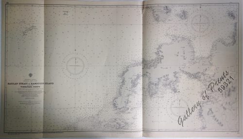
Philippine Islands Mindanao - West Coast - Basilan Strait to Kamiguin Island Including Tubbataha Reefs. From the United States Coast Survey Charts to 1924 with corrections to 1929
1 x
₱
11,000.00
Nuova et Accurata Carta dell 'Isole Filippine... Celebes & c.
1 x
₱
28,600.00
The Murillo Bulletin, Journal of PHIMCOS, Issue No. 15
1 x
₱
790.00
L'Illustration
1 x
₱
6,600.00
The Earthquake at Manilla: 3 views. 1) Nave of the Cathedral after the Earthquake. 2) Tower of Binondo Church after the Earthquake. 3) Ruins of the Danish Consulate
1 x
₱
8,800.00
The Story of the Philippines and our new Possessions
1 x
₱
4,980.00
La Corvette La Favorite au mouillage de Manille (La Favorite Anchored in Manila)
1 x
₱
39,600.00
Océanique: Isles du Scarborough. 'pl. 16 Note sur le nouv. Hollande. Pour le commencement voyez la carte no. 29 ... Pour la suite voyez la carte no. 17. [Notes on New Holland. For the beginning please go to map no. 29….For the continuation please see map no. 17]
1 x
₱
8,800.00
L'Halmature Thétis [Kangaroo] A. Jeune dans le Repos
1 x
₱
11,000.00
Isla de Paragua o Palawan Norte pl. 24 [ Northern Palawan with inset – Bahia de Puerto Princesa]
1 x
₱
7,700.00
Bilalo, bateau de passage de Manille a Cavite. [Manila-Cavite ferry, called a "Bilalo"]
1 x
₱
110,000.00
Mittheilungen aus Justus Perthes' Geographischer Anstalt. über wichtige neue Erforschungen auf dem Gesammtgebiete der Geographie von Dr. A. Petermann. - Ergänzungsband VI, 1869-71 Inhalt: [Supplement Vol. 6 contents] No. 26. Lindemann, die arktische Fischerei der Deutschen Seestädte 1620-1868 No. 27. Payer, die südlichen Ortler-Alpen No. 28. Koldewey und Petermann, die erste Deutsche Nordpolar-Expedition, 1868 No. 29. Petermann, Australien in 1871. Mit geograph.- statistischem Compendium von Meinicke
1 x
₱
14,700.00
The Murillo Bulletin, Journal of PHIMCOS, Issue No. 13
1 x
₱
790.00
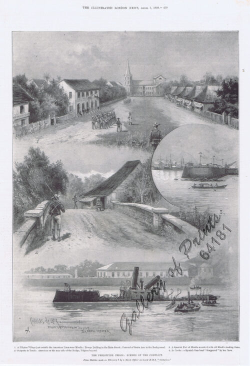
The Philippine Crisis: Scenes of the Conflict. 1. A Filipino Village just outside the American Lines near Manila; 2. Outposts in Touch: American on the near side of the Bridge, Filipino beyond; 3. A Spanish Fort at Manila mounted with old Muzzle-loading Guns; 4. At Cavite: a Spanish Gun-boat “Scuppered” by her Crew.
1 x
₱
6,600.00
1) Constitucion de la Monarquia Española. [Constitution of the Spanish Monarchy] 2) Ley Electoral para el nombramiento de diputados a cortes. [Electoral Law for the appointment of deputies to courts] 3) Reglamento para el gobierno interior del senado. [Regulations for the internal government of the Senate] 4) Reglamento del congreso de diputados; [Regulations of the Congress of Deputies] y ley de 19 de Julio de 1837. [and law of July 19, 1837.]
1 x
₱
6,600.00
Lagerstroemia Regia. Roxb. [Tagalog: Banaba Tree]
1 x
₱
26,400.00
Filipinas. Distrito de Lepanto Description general accompañada de itinerario y croquis del territorio,…
1 x
₱
99,000.00
[Carte Reduite] Carte Réduite des Isles Philippines Pour Servir Aux Vaisseaux du Roy Dressée au Dépost des Cartes Plans et Journaux de la Marine
1 x
₱
425,000.00
Harper's Weekly - A Journal of Civilization with frontispiece: The Sovereigns at the with frontispiece: In The Bitter Cold.
1 x
₱
11,000.00
International Map Collectors' Society IMCoS Journal December 2021 No.167
1 x
₱
1,400.00
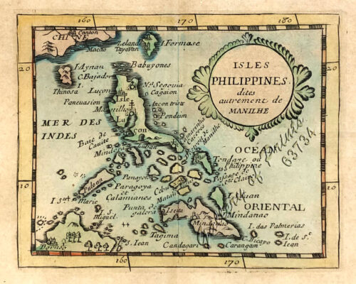
Isles Philippines dites autrement de Manilhe
1 x
₱
49,500.00
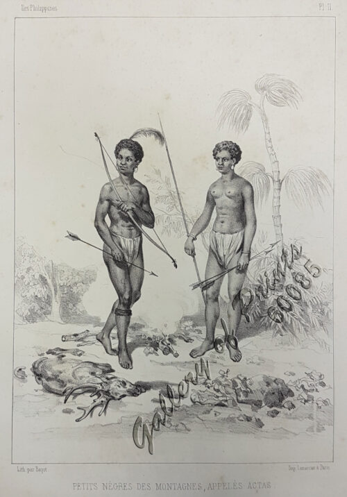
Petits Nègres des Montagnes, Appelés Actas [sic] [Mountain Aborigins called Aetas]
1 x
₱
88,000.00
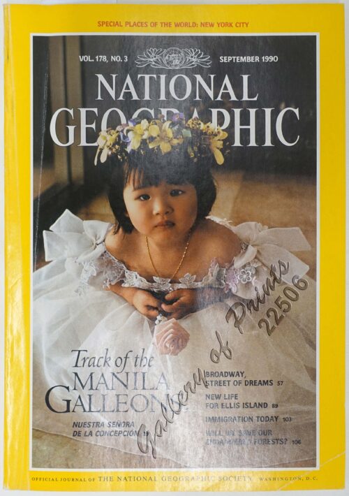
National Geographic September, 1990, Vol. 178, No. 3. Track of the Manila Galleons
1 x
₱
3,300.00
Plan de La Baie de Manille
1 x
₱
39,600.00
Map of the United States showing the Territorial Expansion of a Century 1804 to 1904 insets: 1) The World. 2) Wake Island. 3) Territory of Alaska. 4) Guam Island. 5) Porto Rico. 6) Philippine Islands. 7) Hawaiian Islands. 8) Tutuila, Manua and Smaller Islands of the Samoan Group. 9) Plan of Panama Canal Zone. 10) Plan showing the Thirteen Original States.
1 x
₱
33,100.00
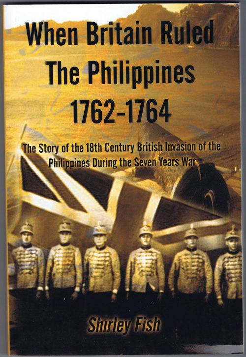
When Britain Ruled the Philippines 1762-1764
1 x
₱
2,900.00
The Inhabitants of the Philippines
1 x
₱
13,200.00
Advertisements [whole page] [page 1043]
1 x
₱
5,500.00
China Sea - Palawan - East Coast - Port Royalist (P.to Princesa de Asturias of the Spanish). Surveyed by Comr. W.T. Bate R.N. Assisted by Lt C. Pasco, C. Bullock, Mate & W.B. Colver 2nd Master H.M.S/ Royalist 1850
1 x
₱
6,600.00
Insulae Philippinae
1 x
₱
220,000.00
Las "Notas" a las Leyes de Indias, de Manuel José de Ayala [The "Notes" to the Laws of the Indies, by Manuel Jose de Ayala]
1 x
₱
4,400.00
A New Map of the East Indies, Taken from Mr. de Fer's Map of Asia, Shewing their Chief Divisions, Cities, Towns, Ports, Rivers, Mountains & c. Dedicated to His Highness William Duke of Glocester.
1 x
₱
49,500.00
The Renewed Conflict in the Philippines: Scenes of the Engagements on February 4 and 5. 1. Santa Ana. 2. Iloilo. 3. Agoncillo, Filipino Agent at Washington. 4. Village of Santa Mesa, the scene of the first fight on February 4. 5. Paco: The Church and Cemetery.
1 x
₱
7,700.00
Isla de Negros pl. 21, with Inset of Bacolod & Surroundings
1 x
₱
6,600.00
View Cart
Checkout
Home
About Us
Publications
Shop Online
Framing Services
Exhibits
Picture Hanging System
Contact Us
View cart
“Isla de Negros pl. 21, with Inset of Bacolod & Surroundings” has been added to your cart.
Sort by
Default Order
Sort by
Default Order
Sort by
Name
Sort by
Price
Sort by
Date
Sort by
Popularity
Show
30 Products
Show
30 Products
Show
60 Products
Show
90 Products
Islas Filipinas
₱
39,600.00
Add to cart
Details
Carte des Indes Orientales… (1e et 2e feuille)
₱
99,000.00
Add to cart
Details
Philippine Islands. Tablas Strait with Part of Sibuyan Sea�...
₱
6,600.00
Add to cart
Details
Les Isles Philippines Molucques et de La Sonde Les Isles du ...
₱
26,400.00
Add to cart
Details
Islas Filipinas. – Grupo de Luzon. inset: [Batanes and...
₱
11,000.00
Add to cart
Details
Islas Filipinas – Mapa General pl. 2, Observatorio d...
₱
5,500.00
Add to cart
Details
Campaña de Filipinas
₱
49,500.00
Add to cart
Details
Manille – Die Stadt Manille [reverse picture] [City of...
₱
22,000.00
Add to cart
Details
Die Vulcane auf Luzon.
₱
11,000.00
Add to cart
Details
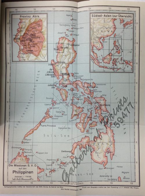
Die Missionen S.V.D auf den Philippinen. [insets:] [1] Provi...
₱
5,500.00
Add to cart
Details
Malaiischer Archipel. insets: 1. Java, 2. Mittel – Luz...
₱
5,500.00
Add to cart
Details
‘Luzon, West Coast – Port Santo Tomas – Li...
₱
2,200.00
Add to cart
Details
Erster Entwurf zu einer Geologischen Uebersichts-Karte von S...
₱
22,000.00
Add to cart
Details
[Sketch of the Area Between San Nicolas to Bambang]
₱
2,200.00
Add to cart
Details
Kanton und Kantonstrom (Canton & the River Canton)
₱
2,200.00
Add to cart
Details
Chart of the Coasts of America & Asia from California to...
₱
9,900.00
Add to cart
Details
Santa Cruz Harbor [Marinduque]
₱
2,200.00
Add to cart
Details
Southern Suburbs of the City of Manila and Vicinity, includi...
₱
4,400.00
Add to cart
Details
Manilhas Bay [untitled chart of Manila Bay]
₱
36,500.00
Add to cart
Details
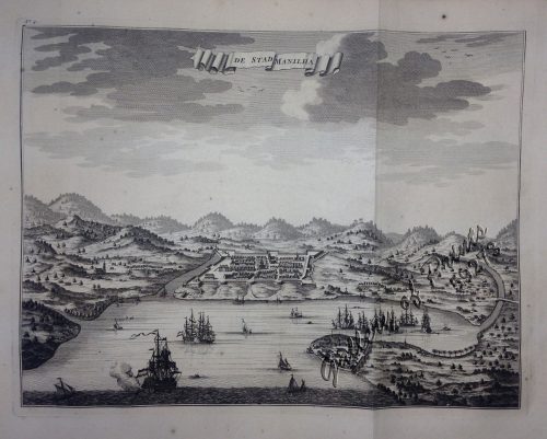
De Stad Manilha
₱
61,600.00
Add to cart
Details
Previous
1
2
3
4
5
…
15
16
17
Next
Shopping Cart
Isla de Negros pl. 21, with Inset of Bacolod & Surroundings
1
The Renewed Conflict in the Philippines: Scenes of the Engagements on February 4 and 5. 1. Santa Ana. 2. Iloilo. 3. Agoncillo, Filipino Agent at Washington. 4. Village of Santa Mesa, the scene of the first fight on February 4. 5. Paco: The Church and Cemetery.
1
A New Map of the East Indies, Taken from Mr. de Fer's Map of Asia, Shewing their Chief Divisions, Cities, Towns, Ports, Rivers, Mountains & c. Dedicated to His Highness William Duke of Glocester.
1
Las "Notas" a las Leyes de Indias, de Manuel José de Ayala [The "Notes" to the Laws of the Indies, by Manuel Jose de Ayala]
1
Insulae Philippinae
1
China Sea - Palawan - East Coast - Port Royalist (P.to Princesa de Asturias of the Spanish). Surveyed by Comr. W.T. Bate R.N. Assisted by Lt C. Pasco, C. Bullock, Mate & W.B. Colver 2nd Master H.M.S/ Royalist 1850
1
Advertisements [whole page] [page 1043]
1
The Inhabitants of the Philippines
1
When Britain Ruled the Philippines 1762-1764
1
Map of the United States showing the Territorial Expansion of a Century 1804 to 1904 insets: 1) The World. 2) Wake Island. 3) Territory of Alaska. 4) Guam Island. 5) Porto Rico. 6) Philippine Islands. 7) Hawaiian Islands. 8) Tutuila, Manua and Smaller Islands of the Samoan Group. 9) Plan of Panama Canal Zone. 10) Plan showing the Thirteen Original States.
1
Plan de La Baie de Manille
1
National Geographic September, 1990, Vol. 178, No. 3. Track of the Manila Galleons
1
Petits Nègres des Montagnes, Appelés Actas [sic] [Mountain Aborigins called Aetas]
1
Isles Philippines dites autrement de Manilhe
1
International Map Collectors' Society IMCoS Journal December 2021 No.167
1
Harper's Weekly - A Journal of Civilization with frontispiece: The Sovereigns at the with frontispiece: In The Bitter Cold.
1
[Carte Reduite] Carte Réduite des Isles Philippines Pour Servir Aux Vaisseaux du Roy Dressée au Dépost des Cartes Plans et Journaux de la Marine
1
Filipinas. Distrito de Lepanto Description general accompañada de itinerario y croquis del territorio,…
1
Lagerstroemia Regia. Roxb. [Tagalog: Banaba Tree]
1
1) Constitucion de la Monarquia Española. [Constitution of the Spanish Monarchy] 2) Ley Electoral para el nombramiento de diputados a cortes. [Electoral Law for the appointment of deputies to courts] 3) Reglamento para el gobierno interior del senado. [Regulations for the internal government of the Senate] 4) Reglamento del congreso de diputados; [Regulations of the Congress of Deputies] y ley de 19 de Julio de 1837. [and law of July 19, 1837.]
1
The Philippine Crisis: Scenes of the Conflict. 1. A Filipino Village just outside the American Lines near Manila; 2. Outposts in Touch: American on the near side of the Bridge, Filipino beyond; 3. A Spanish Fort at Manila mounted with old Muzzle-loading Guns; 4. At Cavite: a Spanish Gun-boat “Scuppered” by her Crew.
1
The Murillo Bulletin, Journal of PHIMCOS, Issue No. 13
1
Mittheilungen aus Justus Perthes' Geographischer Anstalt. über wichtige neue Erforschungen auf dem Gesammtgebiete der Geographie von Dr. A. Petermann. - Ergänzungsband VI, 1869-71 Inhalt: [Supplement Vol. 6 contents] No. 26. Lindemann, die arktische Fischerei der Deutschen Seestädte 1620-1868 No. 27. Payer, die südlichen Ortler-Alpen No. 28. Koldewey und Petermann, die erste Deutsche Nordpolar-Expedition, 1868 No. 29. Petermann, Australien in 1871. Mit geograph.- statistischem Compendium von Meinicke
1
Bilalo, bateau de passage de Manille a Cavite. [Manila-Cavite ferry, called a "Bilalo"]
1
Isla de Paragua o Palawan Norte pl. 24 [ Northern Palawan with inset – Bahia de Puerto Princesa]
1
L'Halmature Thétis [Kangaroo] A. Jeune dans le Repos
1
Océanique: Isles du Scarborough. 'pl. 16 Note sur le nouv. Hollande. Pour le commencement voyez la carte no. 29 ... Pour la suite voyez la carte no. 17. [Notes on New Holland. For the beginning please go to map no. 29….For the continuation please see map no. 17]
1
La Corvette La Favorite au mouillage de Manille (La Favorite Anchored in Manila)
1
The Story of the Philippines and our new Possessions
1
The Earthquake at Manilla: 3 views. 1) Nave of the Cathedral after the Earthquake. 2) Tower of Binondo Church after the Earthquake. 3) Ruins of the Danish Consulate
1
L'Illustration
1
The Murillo Bulletin, Journal of PHIMCOS, Issue No. 15
1
Nuova et Accurata Carta dell 'Isole Filippine... Celebes & c.
1
Philippine Islands Mindanao - West Coast - Basilan Strait to Kamiguin Island Including Tubbataha Reefs. From the United States Coast Survey Charts to 1924 with corrections to 1929
1
Cart
Checkout
Continue Shopping
34