Tel : +63(2)-7729-8168
|
Email Us : gallery@gop.com.ph
My Account
Remember Me
Register
7 Item(s)
-
₱
1,355,190.00
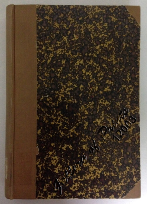
Reisen in den Philippinen [Travels in the Philippines] [with appendices: Ueber die geologische Beschaffenheit der Philippinen [On the Geological State of the Ph] Ueber alte und neue Schädel von den Philippinen [On Old and New Skulls of the Ph] with notes on the taxes etc.]
1 x
₱
99,000.00
[Carte Reduite] Carte Réduite des Isles Philippines Pour Servir Aux Vaisseaux du Roy Dressée au Dépost des Cartes Plans et Journaux de la Marine
1 x
₱
425,000.00
The Murillo Bulletin, Journal of PHIMCOS, Issue No. 15
1 x
₱
790.00
Map of the United States showing the Territorial Expansion of a Century 1804 to 1904 insets: 1) The World. 2) Wake Island. 3) Territory of Alaska. 4) Guam Island. 5) Porto Rico. 6) Philippine Islands. 7) Hawaiian Islands. 8) Tutuila, Manua and Smaller Islands of the Samoan Group. 9) Plan of Panama Canal Zone. 10) Plan showing the Thirteen Original States.
1 x
₱
33,100.00
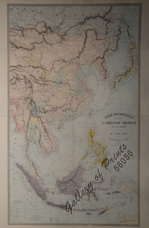
Indie Orientale [Indochina] [China, Korea, Philippines] [Japan, Guam, Pacific]
1 x
₱
790,000.00
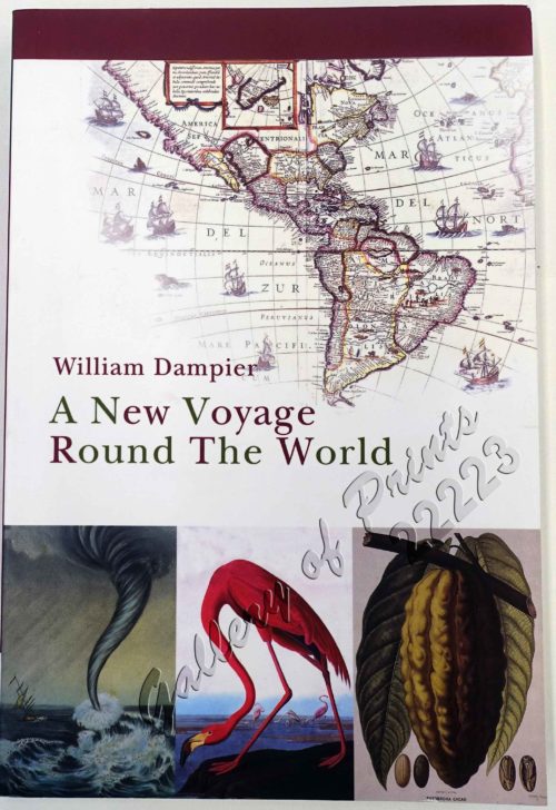
A New Voyage Round The World. The Journal of an English Buccaneer.
1 x
₱
2,900.00
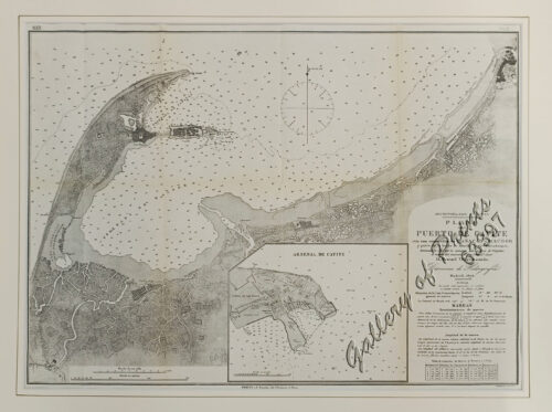
Archipiélago Filipino - Isla de Mindanao Plano del Puerto de Pollok
1 x
₱
4,400.00
View Cart
Checkout
Home
About Us
Publications
Shop Online
Framing Services
Exhibits
Picture Hanging System
Contact Us
Sorry, this product cannot be purchased.
View cart
“Archipiélago Filipino – Isla de Mindanao Plano del Puerto de Pollok” has been added to your cart.
Sort by
Name
Sort by
Default Order
Sort by
Name
Sort by
Price
Sort by
Date
Sort by
Popularity
Show
30 Products
Show
30 Products
Show
60 Products
Show
90 Products
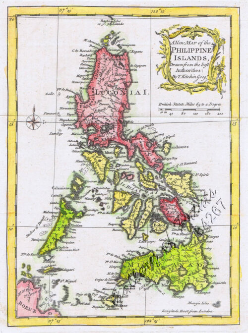
A New Map of the Philippine Islands, Drawn from the best Aut...
₱
77,000.00
Add to cart
Details
A New Map of the World according to Wright’s alias Mer...
₱
125,000.00
Add to cart
Details
A Plan of the Bay of Manila / A Plan of the Harbour of Acapu...
₱
39,600.00
Add to cart
Details
A Plan of the Bay of Manila / A Plan of the Harbour of Acapu...
₱
39,600.00
Add to cart
Details
a) bezeichnet den Lauf der Gallion Nuestra Señora de Cabado...
₱
26,400.00
Add to cart
Details
AAF Aeronautical Chart No. 620, Babuyan Islands Scale 1:1,...
₱
11,000.00
Add to cart
Details
AAF Cloth Chart – Philippine Series No. C-41, Mindoro ...
₱
46,500.00
Add to cart
Details
Acciones y operaciones sobre Silang. (Desde el 15 al 18 Febr...
₱
7,700.00
Add to cart
Details
Action between 28″ Inf. U.S.V. and Filipino Rebels Jul...
₱
5,500.00
Add to cart
Details
Afrique Meridionale
₱
5,500.00
Add to cart
Details
America Septentrionalis Coloniis in Interiorem Virginiam ded...
₱
15,700.00
Add to cart
Details
Archipel Asiatique. inset maps: 1. Manille et Environs. 2. L...
₱
15,700.00
Add to cart
Details
Archipel de Jolo
₱
3,300.00
Add to cart
Details
Archipel des Indes Orientales, qui comprend Les Isles de la ...
₱
34,100.00
Add to cart
Details
Archipiélago Filipino – Isla de Mindanao Plano del Pu...
₱
4,400.00
Add to cart
Details
Archipiélago Filipino. Plano del Puerto de Cavite con sus e...
₱
9,900.00
Add to cart
Details
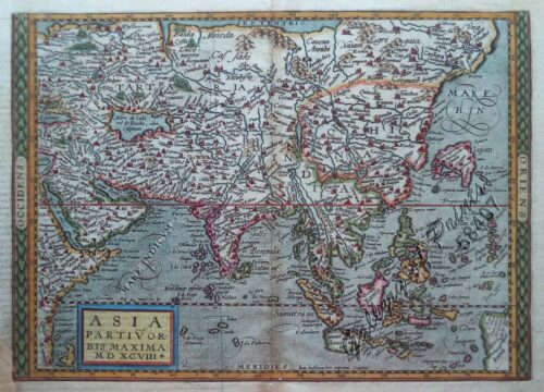
Asia partiu orbis maxima. MDXCVIII.
₱
61,600.00
Add to cart
Details
Asia wie es jetziger Zeit…
₱
49,500.00
Add to cart
Details
Asiae Recentissima Delineatio, Qua Status ex Imperia Totius...
₱
39,600.00
Add to cart
Details
Asie orientale comprenant l’empire Chinois et le Japon...
₱
42,900.00
Add to cart
Details
Asie: Partie de la Chine pl. 88
₱
19,700.00
Add to cart
Details
Asien Politische Übersicht [Asia Political Overview]
₱
5,500.00
Add to cart
Details
Asien. (Übersicht.)
₱
6,600.00
Add to cart
Details
Bacolod Fort
₱
3,300.00
Add to cart
Details
Bahia de Manila
₱
46,200.00
Add to cart
Details
Bahia de Manila pl. 29 inset: Manila
₱
7,700.00
Add to cart
Details
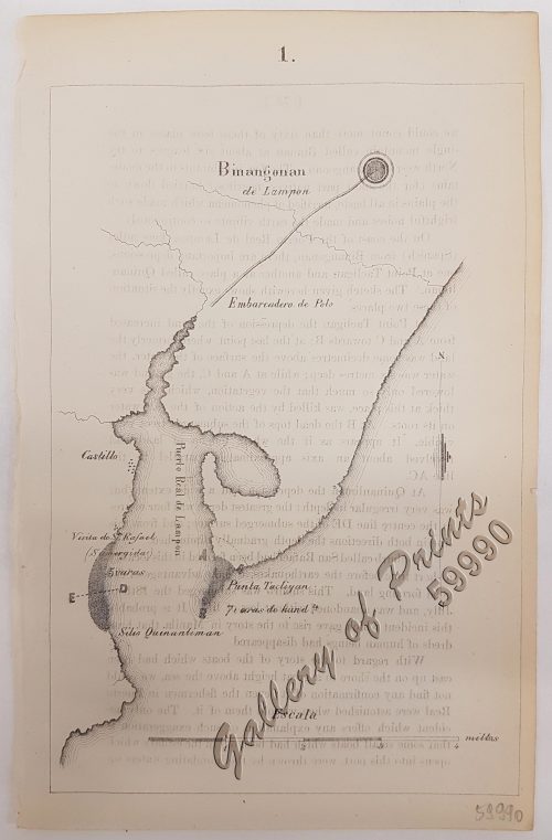
Binangonan
₱
6,600.00
Add to cart
Details
Previous
1
2
3
4
5
…
15
16
17
Next
Shopping Cart
Archipiélago Filipino - Isla de Mindanao Plano del Puerto de Pollok
1
A New Voyage Round The World. The Journal of an English Buccaneer.
1
Indie Orientale [Indochina] [China, Korea, Philippines] [Japan, Guam, Pacific]
1
Map of the United States showing the Territorial Expansion of a Century 1804 to 1904 insets: 1) The World. 2) Wake Island. 3) Territory of Alaska. 4) Guam Island. 5) Porto Rico. 6) Philippine Islands. 7) Hawaiian Islands. 8) Tutuila, Manua and Smaller Islands of the Samoan Group. 9) Plan of Panama Canal Zone. 10) Plan showing the Thirteen Original States.
1
The Murillo Bulletin, Journal of PHIMCOS, Issue No. 15
1
[Carte Reduite] Carte Réduite des Isles Philippines Pour Servir Aux Vaisseaux du Roy Dressée au Dépost des Cartes Plans et Journaux de la Marine
1
Reisen in den Philippinen [Travels in the Philippines] [with appendices: Ueber die geologische Beschaffenheit der Philippinen [On the Geological State of the Ph] Ueber alte und neue Schädel von den Philippinen [On Old and New Skulls of the Ph] with notes on the taxes etc.]
1
Cart
Checkout
Continue Shopping
7