Tel : +63(2)-7729-8168
|
Email Us : gallery@gop.com.ph
My Account
Remember Me
Register
23 Item(s)
-
₱
661,950.00
The Trouble in the Philippines: American Troops Entering San Fernando
1 x
₱
7,700.00
Expedición a Joló, 1876: Bocetos del Cronista del Diario de Manila [Expedition to Joló, 1876: Sketches of the Chronicler of the Diario de Manila]
1 x
₱
4,500.00
China Sea - Macclesfield Bank. Surveyed by Commander W.U. Moore and the Officers of H.M. Surveying Ship Penguin, 1892. and by Commander A. Mostyn Field and the Officers of H.M. Surveying Ship Egeria,1893.
1 x
₱
6,600.00
The Philippine Islands
1 x
₱
7,700.00
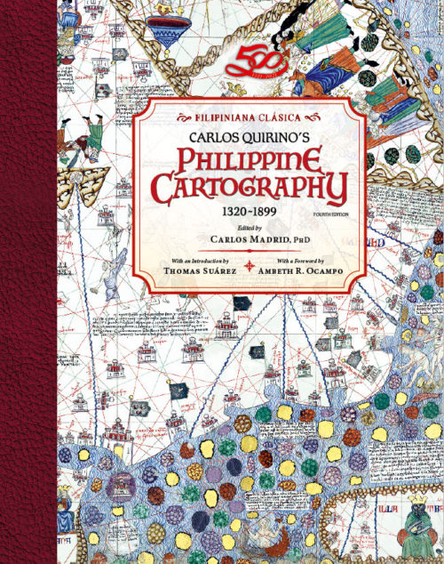
Philippine Cartography 1320-1899
1 x
₱
11,000.00
Harper's Weekly - A Journal of Civilization with frontispiece: The Sovereigns at the Theatre at Stuttgardt.
1 x
₱
13,200.00
The Un-Discovered Islands An Archipelago of Myths and Mysteries, Phantoms and Fakes
1 x
₱
2,500.00
Islas Filipinas - Mapa Etnografico pl. 3, Observatorio de Manila
1 x
₱
6,600.00
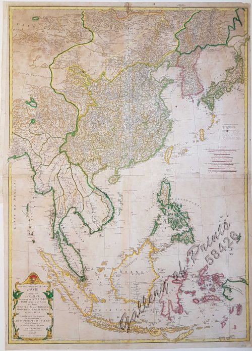
Seconde partie de la Carte d'Asie contenant la Chine et partie de la Tartarie, l'Inde au delà du Gange, les Isles Sumatra, Java, Borneo, Moluques, Philippines, et du Japon.
1 x
₱
39,600.00
Another Report About Magellan's Circumnavigation of the World. The Compilation by Fernando Oliveira. Revised and Expanded Edition
1 x
₱
900.00
[Sailing Boat] [illegible title]
1 x
₱
5,500.00
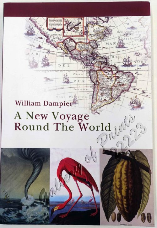
A New Voyage Round The World. The Journal of an English Buccaneer.
1 x
₱
2,900.00
Isla de Paragua o Palawan Norte pl. 24 [ Northern Palawan with inset – Bahia de Puerto Princesa]
1 x
₱
7,700.00
Germany, the Philippines, and the Spanish American War.
1 x
₱
550.00
India Orientalis
1 x
₱
39,600.00
Map of the United States showing the Territorial Expansion of a Century 1804 to 1904 insets: 1) The World. 2) Wake Island. 3) Territory of Alaska. 4) Guam Island. 5) Porto Rico. 6) Philippine Islands. 7) Hawaiian Islands. 8) Tutuila, Manua and Smaller Islands of the Samoan Group. 9) Plan of Panama Canal Zone. 10) Plan showing the Thirteen Original States.
1 x
₱
33,100.00
Isla de Negros pl. 21, with Inset of Bacolod & Surroundings
1 x
₱
6,600.00
Harper's Weekly - A Journal of Civilization with frontispiece: The Sovereigns at the with frontispiece: In The Bitter Cold.
1 x
₱
11,000.00
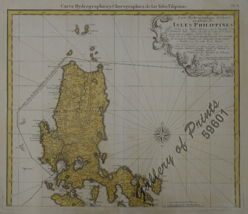
Carte Hydrographique & Chorographique des Isles Philippines (Carta Hydrographica y Chorographica de las Ysles Filipinas)
1 x
₱
425,000.00
The Illustrated London News Vol. 32 - No. 897
1 x
₱
6,600.00
Carte des Isles Philippines, Celebes et Moluques [Kaart van de Filippynse, Celebes, en Molukse-Eilanden]
1 x
₱
13,200.00
Pacifico - Islas Filipinas pl. 1
1 x
₱
6,600.00
Archipel de Jolo
1 x
₱
3,300.00
View Cart
Checkout
Home
About Us
Publications
Shop Online
Framing Services
Exhibits
Picture Hanging System
Contact Us
View cart
“Archipel de Jolo” has been added to your cart.
Sort by
Price
Sort by
Default Order
Sort by
Name
Sort by
Price
Sort by
Date
Sort by
Popularity
Show
30 Products
Show
30 Products
Show
60 Products
Show
90 Products
Karte der Philippinen zur Darstellung der Ethnographischen V...
Details
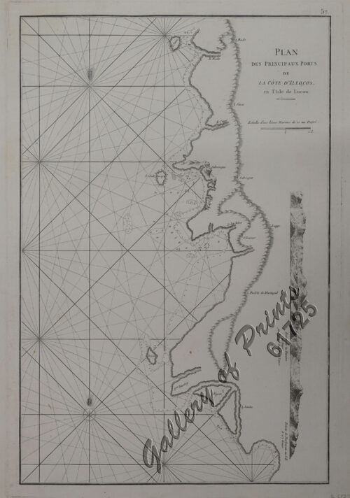
Plan des principaux ports de la côte d’Illocos … [M...
₱
1,100.00
Add to cart
Details
‘Luzon, West Coast – Port Santo Tomas – Li...
₱
2,200.00
Add to cart
Details
[Sketch of the Area Between San Nicolas to Bambang]
₱
2,200.00
Add to cart
Details
Kanton und Kantonstrom (Canton & the River Canton)
₱
2,200.00
Add to cart
Details
Santa Cruz Harbor [Marinduque]
₱
2,200.00
Add to cart
Details
Fort Ganassi Near Lake Lanao, Mindanao
₱
2,200.00
Add to cart
Details
Engagement of March 7, 1899 [Near San Pedro Macati, Luzon
₱
2,200.00
Add to cart
Details
Von Luzon nach Hongkong
₱
2,200.00
Add to cart
Details
‘XIV. Von Schanghai nach Guaham und Puynipet. [Carolin...
₱
3,300.00
Add to cart
Details
Archipel de Jolo
₱
3,300.00
Add to cart
Details
Bacolod Fort
₱
3,300.00
Add to cart
Details
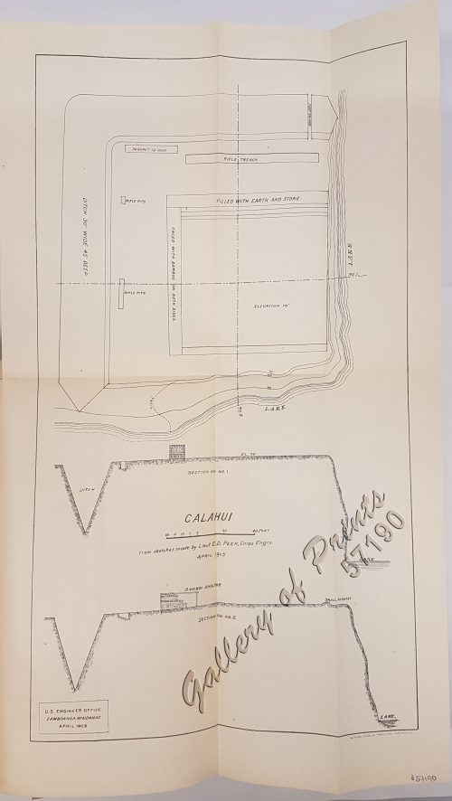
Calahui
₱
3,300.00
Add to cart
Details
Military Establishment at Tjimahl, Cantonment of the 6th Bat...
₱
3,300.00
Add to cart
Details
Luban Island Looc Bay
₱
3,300.00
Add to cart
Details
Costa S. De Mindanao Plano Nuevo del Fondeadero de Masingloc...
₱
3,300.00
Add to cart
Details
Puerto de Surigao
₱
3,300.00
Add to cart
Details
Mindoro I. – Paluan Bay
₱
3,300.00
Add to cart
Details
Island of Luzon. inset map: Islands of the Philippines north...
₱
3,300.00
Add to cart
Details
Chart of Port IloIlo and Panay
₱
4,400.00
Add to cart
Details
East Indies
₱
4,400.00
Add to cart
Details
Previous
1
2
3
4
5
…
15
16
17
Next
Shopping Cart
Archipel de Jolo
1
Pacifico - Islas Filipinas pl. 1
1
Carte des Isles Philippines, Celebes et Moluques [Kaart van de Filippynse, Celebes, en Molukse-Eilanden]
1
The Illustrated London News Vol. 32 - No. 897
1
Carte Hydrographique & Chorographique des Isles Philippines (Carta Hydrographica y Chorographica de las Ysles Filipinas)
1
Harper's Weekly - A Journal of Civilization with frontispiece: The Sovereigns at the with frontispiece: In The Bitter Cold.
1
Isla de Negros pl. 21, with Inset of Bacolod & Surroundings
1
Map of the United States showing the Territorial Expansion of a Century 1804 to 1904 insets: 1) The World. 2) Wake Island. 3) Territory of Alaska. 4) Guam Island. 5) Porto Rico. 6) Philippine Islands. 7) Hawaiian Islands. 8) Tutuila, Manua and Smaller Islands of the Samoan Group. 9) Plan of Panama Canal Zone. 10) Plan showing the Thirteen Original States.
1
India Orientalis
1
Germany, the Philippines, and the Spanish American War.
1
Isla de Paragua o Palawan Norte pl. 24 [ Northern Palawan with inset – Bahia de Puerto Princesa]
1
A New Voyage Round The World. The Journal of an English Buccaneer.
1
[Sailing Boat] [illegible title]
1
Another Report About Magellan's Circumnavigation of the World. The Compilation by Fernando Oliveira. Revised and Expanded Edition
1
Seconde partie de la Carte d'Asie contenant la Chine et partie de la Tartarie, l'Inde au delà du Gange, les Isles Sumatra, Java, Borneo, Moluques, Philippines, et du Japon.
1
Islas Filipinas - Mapa Etnografico pl. 3, Observatorio de Manila
1
The Un-Discovered Islands An Archipelago of Myths and Mysteries, Phantoms and Fakes
1
Harper's Weekly - A Journal of Civilization with frontispiece: The Sovereigns at the Theatre at Stuttgardt.
1
Philippine Cartography 1320-1899
1
The Philippine Islands
1
China Sea - Macclesfield Bank. Surveyed by Commander W.U. Moore and the Officers of H.M. Surveying Ship Penguin, 1892. and by Commander A. Mostyn Field and the Officers of H.M. Surveying Ship Egeria,1893.
1
Expedición a Joló, 1876: Bocetos del Cronista del Diario de Manila [Expedition to Joló, 1876: Sketches of the Chronicler of the Diario de Manila]
1
The Trouble in the Philippines: American Troops Entering San Fernando
1
Cart
Checkout
Continue Shopping
23