Tel : +63(2)-7729-8168
|
Email Us : gallery@gop.com.ph
My Account
Remember Me
Register
25 Item(s)
-
₱
1,558,600.00
A Plan of the Bay of Manila / A Plan of the Harbour of Acapulco / A View of 2 of the Ladrone Islands
1 x
₱
39,600.00
Kanton und Kantonstrom (Canton & the River Canton)
1 x
₱
2,200.00
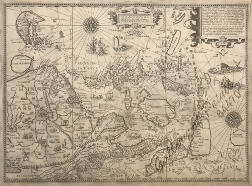
Exacta & accurata delineatio cum orarum maritimarum tum etjam locorum terrestrium quae in Regionibus China, Cauchinchina, Camboja sive Champa, Syao, Malacca, Arracan & Pegu… Waarachtige uitworpinghe ofte afbeeldinge van alle die custen ende landen van China, … [Accurate & Detailed Drawing with Borders Maritime and even Terrestrial Places Located in the Regions of China….]
1 x
₱
1,100,000.00
Amherstia Nobilis [Pride of Burma or Orchid Tree, (Fabaceae family)] [Local Name: Queen of Flowering Trees]
1 x
₱
26,400.00
Rivière Sagaliud, Golfe de Sandakan
1 x
₱
3,300.00
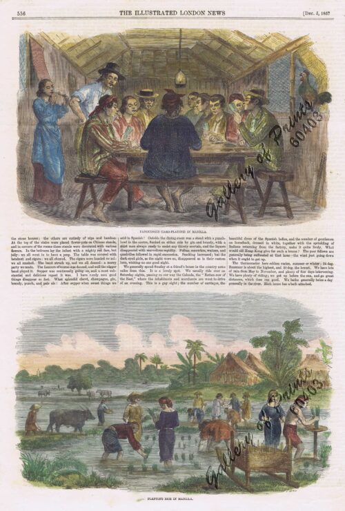
1. Panguingui (Card-playing) in Manilla; 2. Planting Rice in Manilla
1 x
₱
11,000.00
The Hakluyt Society. The Travels and Controversies of Friar Domingo Navarette (1618-1686). Second Series: No. 118 [volume I] Second Series: No. 119 [volume II]
1 x
₱
6,600.00
Épisode de l'attaque des juramentados
1 x
₱
4,400.00
The Chinese Mestizo in Philippine History
1 x
₱
3,300.00
Die Ostindischen Inseln...
1 x
₱
39,600.00
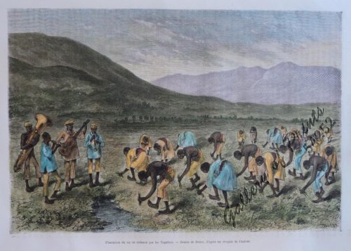
Plantation du riz en cadence par les Tagalocs [Tagalogs Planting Rice in Musical Tact]
1 x
₱
5,500.00
The Philippines in the 19th Century (A Collection of Prints)
1 x
₱
3,500.00
A Map of the East Indies from the latest Authorities and Observations By John Blair L.L.D. & F.R.S. As a Supplement to His Tables of Chronology. [inset:] The Philippine Islands.
1 x
₱
26,400.00
Interior of the Crater of the Volcano at Taal
1 x
₱
8,800.00
Chart of Zamboanga
1 x
₱
4,400.00
Map of the United States showing the Territorial Expansion of a Century 1804 to 1904 insets: 1) The World. 2) Wake Island. 3) Territory of Alaska. 4) Guam Island. 5) Porto Rico. 6) Philippine Islands. 7) Hawaiian Islands. 8) Tutuila, Manua and Smaller Islands of the Samoan Group. 9) Plan of Panama Canal Zone. 10) Plan showing the Thirteen Original States.
1 x
₱
33,100.00
Spathiphyllopsis Minahassae. T. et B. [Spathiphyllum]
1 x
₱
26,400.00
Cochinchine - Philippines 1. Femmes Cochinchinoises. 2. Tagals
1 x
₱
39,600.00
Die Igorot Bergvölker in den Philippinen heute [Mountain Tribes in the Philippines Today] Leitfaden zu der Ausstellung [Guide to the Exhibit]
1 x
₱
2,900.00
1) Vue de la rivière Passig dans l'île Luçon. 2) Vue de Manila, capitale de l'île Luçon. (Iles Philippines.)
1 x
₱
99,000.00
Park in Tokio
1 x
₱
4,400.00
Map showing Locations of Temporary Field Works Erected by the Spanish for The Land Defense of Havana, 1897-1898.
1 x
₱
13,200.00
Bibliography of the Philippine Islands. Printed and Manuscript. Preceded by a Descriptive Account of the most important Archives and Collections containing Philippina
1 x
₱
4,400.00
Archipel des Indes Orientales, qui comprend Les Isles de la Sonde, Moluques et Philippines… inset: Isles Marianes ou des Larons.
1 x
₱
34,100.00
Location of Troops in the Philippine Islands March 31, 1900.
1 x
₱
16,500.00
View Cart
Checkout
Home
About Us
Publications
Shop Online
Framing Services
Exhibits
Picture Hanging System
Contact Us
View cart
“Location of Troops in the Philippine Islands March 31, 1900.” has been added to your cart.
Sort by
Price
Sort by
Default Order
Sort by
Name
Sort by
Price
Sort by
Date
Sort by
Popularity
Show
30 Products
Show
30 Products
Show
60 Products
Show
90 Products
1. Plantain. (Banana Tree), 2. Papaw Leaf and Tree, 3. Cocoa...
₱
2,200.00
Add to cart
Details
Luban Island Looc Bay
₱
3,300.00
Add to cart
Details
Costa S. De Mindanao Plano Nuevo del Fondeadero de Masingloc...
₱
3,300.00
Add to cart
Details
Puerto de Surigao
₱
3,300.00
Add to cart
Details
Mindoro I. – Paluan Bay
₱
3,300.00
Add to cart
Details
Bamboo Signal Used by Natives in Marinduque
₱
3,300.00
Add to cart
Details
14. Spotted Kingfisher. (Alcedo guttatus)
₱
3,300.00
Add to cart
Details
Lasiocampidæ. Fig. 1, a, b, c. Gastropacha Quercifolia. Fi...
₱
3,300.00
Add to cart
Details
Zygænidæ – Syntomidæ. Fig. 1. Aglaope Infausta. Fi...
₱
3,300.00
Add to cart
Details
Class VII Umbrellate, Class VIII Caryophyllous, Class IX Lil...
₱
4,400.00
Add to cart
Details
The Operations Before Manila – A Daring Reconnoissanc...
₱
4,400.00
Add to cart
Details
Islas Filipinas – Mapa Orografico Observatorio de Mani...
₱
4,400.00
Add to cart
Details
Inside the churches of Manila…
₱
4,400.00
Add to cart
Details
Philippinen – Exotische Inselwelt La vie exotique des ...
₱
4,400.00
Add to cart
Details
Military Establishment at Tjimahl, Cantonment of the 6th Bat...
₱
4,400.00
Add to cart
Details
Demande en mariage chez les Bagobos (Mindanao) [Marriage Pr...
₱
4,400.00
Add to cart
Details
Bazar de Luçon à Manille, après le tremblement de terre. ...
₱
4,400.00
Add to cart
Details
Ruines de Siniloan. [Ruins of Siniloan.]
₱
4,400.00
Add to cart
Details
Mouth of the Bay of Manilla.
₱
4,400.00
Add to cart
Details
Arroyo sur la côte orientale de Mindanao [East Coast of Min...
₱
4,400.00
Add to cart
Details
Luzon Island inset: Vicinity of Manila
₱
4,400.00
Add to cart
Details
Promerops [Bird of Paradise]
₱
4,400.00
Add to cart
Details
1
2
3
4
…
8
9
10
Next
Shopping Cart
Location of Troops in the Philippine Islands March 31, 1900.
1
Archipel des Indes Orientales, qui comprend Les Isles de la Sonde, Moluques et Philippines… inset: Isles Marianes ou des Larons.
1
Bibliography of the Philippine Islands. Printed and Manuscript. Preceded by a Descriptive Account of the most important Archives and Collections containing Philippina
1
Map showing Locations of Temporary Field Works Erected by the Spanish for The Land Defense of Havana, 1897-1898.
1
Park in Tokio
1
1) Vue de la rivière Passig dans l'île Luçon. 2) Vue de Manila, capitale de l'île Luçon. (Iles Philippines.)
1
Die Igorot Bergvölker in den Philippinen heute [Mountain Tribes in the Philippines Today] Leitfaden zu der Ausstellung [Guide to the Exhibit]
1
Cochinchine - Philippines 1. Femmes Cochinchinoises. 2. Tagals
1
Spathiphyllopsis Minahassae. T. et B. [Spathiphyllum]
1
Map of the United States showing the Territorial Expansion of a Century 1804 to 1904 insets: 1) The World. 2) Wake Island. 3) Territory of Alaska. 4) Guam Island. 5) Porto Rico. 6) Philippine Islands. 7) Hawaiian Islands. 8) Tutuila, Manua and Smaller Islands of the Samoan Group. 9) Plan of Panama Canal Zone. 10) Plan showing the Thirteen Original States.
1
Chart of Zamboanga
1
Interior of the Crater of the Volcano at Taal
1
A Map of the East Indies from the latest Authorities and Observations By John Blair L.L.D. & F.R.S. As a Supplement to His Tables of Chronology. [inset:] The Philippine Islands.
1
The Philippines in the 19th Century (A Collection of Prints)
-
Quantity
+
Plantation du riz en cadence par les Tagalocs [Tagalogs Planting Rice in Musical Tact]
1
Die Ostindischen Inseln...
1
The Chinese Mestizo in Philippine History
1
Épisode de l'attaque des juramentados
1
The Hakluyt Society. The Travels and Controversies of Friar Domingo Navarette (1618-1686). Second Series: No. 118 [volume I] Second Series: No. 119 [volume II]
1
1. Panguingui (Card-playing) in Manilla; 2. Planting Rice in Manilla
1
Rivière Sagaliud, Golfe de Sandakan
1
Amherstia Nobilis [Pride of Burma or Orchid Tree, (Fabaceae family)] [Local Name: Queen of Flowering Trees]
1
Exacta & accurata delineatio cum orarum maritimarum tum etjam locorum terrestrium quae in Regionibus China, Cauchinchina, Camboja sive Champa, Syao, Malacca, Arracan & Pegu… Waarachtige uitworpinghe ofte afbeeldinge van alle die custen ende landen van China, … [Accurate & Detailed Drawing with Borders Maritime and even Terrestrial Places Located in the Regions of China….]
1
Kanton und Kantonstrom (Canton & the River Canton)
1
A Plan of the Bay of Manila / A Plan of the Harbour of Acapulco / A View of 2 of the Ladrone Islands
1
Cart
Checkout
Continue Shopping
25