Tel : +63(2)-7729-8168
|
Email Us : gallery@gop.com.ph
My Account
Remember Me
Register
16 Item(s)
-
₱
593,300.00
Salmon
1 x
₱
5,500.00
The Luneta, Manila
1 x
₱
3,300.00
Lettres édifiantes et curieuses, ecrites des Missions Etrangeres, par quelques Missionaires de la Compagnie de Jesus; Epitre du Halde, Lettres des…Bouchet (Inde), Taillandier), Relation …deconverte …nouvelles Philippines [pp. 75-91]…Dentrecolles, Jacquemin (Chine), Gabriel (illinois), Sepp (Paraguay)
1 x
₱
29,500.00
1. Carte de la baie de Manille. 2. Carte générale de îles Philippines. 3. Baie de Cavite. 4. Diagrame de forces respectives des eccadres américaine et espagnole au combat de Manille.
1 x
₱
6,600.00
Bamboo Signal Used by Natives in Marinduque
1 x
₱
3,300.00
1) Plan of Solsogon Harbour on the South Coast of Luconia. 2) Chart on the Eastern Coast of Bongo Bay in the Island of Mindanao.
1 x
₱
36,500.00
1) Le Pic de la Encenada. [The Peak of Encenada] 2) Le Pic Cardinal. [The Cardinal Peak] 3) Le Pic verd. [The Green Peak] 4) Le Pic verd de l'Isle de Luçon. [The Green Peak in the Island of Luzon]
1 x
₱
6,600.00
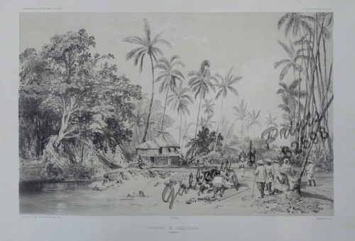
Environs de Samboangan (Ile Mindanao)
1 x
₱
33,900.00
Entrée de la baie de Manille, (Iles Philippines) Entrevue nocturne de l'Auteur avec les petits noirs des Montagnes. [Entrance of Manila Bay (Philippine Islands) Nocturnal Meeting of the Author With the Native Mountain People]
1 x
₱
298,000.00
Harper's Weekly - A Journal of Civilization with frontispiece: Ice-Yachting-Hard-A-Lee! Drawn by W. P. Snyder.
1 x
₱
7,700.00
A Plan of the Bay of Manila / A Plan of the Harbour of Acapulco / A View of 2 of the Ladrone Islands
1 x
₱
39,600.00
1. Pirogue de peche de la baie de Manille [Fishing canoe from Manila Bay] 2. Plan 3. Elevation de l'arriere [Rear Elevation] 4. Section 5. & 6. Avirons [Oars] 7. Petite pirogue [Small Canoe] 8. Plan 9. Elevation de l'arriere [Rear Elevation]
1 x
₱
50,600.00
Philippine Islands. Luzon Island. North of Latitude 16° 20' North. From the United States Cost Survey Charts to 1925. With additions and correctionsfrom the Philippine Gov't. Charts to 1963. Soundings in hairline enlarged from smaller scale charts.
1 x
₱
11,000.00
Chart of the Coast of China and of the Japan Islands including the Marianes and a part of the Philippines. Compiled by order of Commodore M. C. Perry. U.S.N. from the latest authorities with additions and corrections by the U.S. Japan Expedition by Lieuts. W. L. Maury and S. Bent. U.S.N.
1 x
₱
39,600.00
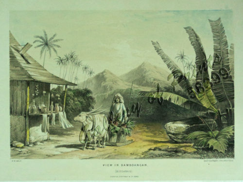
View in Samboangan. (Mindanao)
1 x
₱
17,200.00
Panay I. - Port Batan
1 x
₱
4,400.00
View Cart
Checkout
Home
About Us
Publications
Shop Online
Framing Services
Exhibits
Picture Hanging System
Contact Us
View cart
“Panay I. – Port Batan” has been added to your cart.
Sort by
Date
Sort by
Default Order
Sort by
Name
Sort by
Price
Sort by
Date
Sort by
Popularity
Show
30 Products
Show
30 Products
Show
60 Products
Show
90 Products
East India Archipelago [Eastern Passages to China and Japan...
₱
49,600.00
Add to cart
Details
Peace and Prosperity General Aguinaldo and Director of Educa...
₱
5,500.00
Add to cart
Details
Sketches from Manilla and Hongkong Chinese Nursemaid on the ...
₱
6,600.00
Add to cart
Details
Map of Northern Luzon Showing a portion of the field of oper...
₱
46,100.00
Add to cart
Details
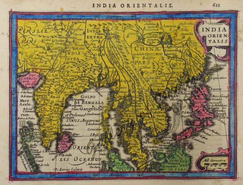
India Orientalis
₱
39,600.00
Add to cart
Details
India Orientalis
₱
39,600.00
Add to cart
Details
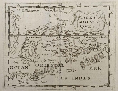
Isole Molucche
₱
33,000.00
Add to cart
Details
Coucou, des Philippines [Philippine Coucal] [Sabukot/ Tsabuk...
₱
18,700.00
Add to cart
Details
Round the World Yachting in the “Ceylon”, XVII.-...
₱
7,700.00
Add to cart
Details
Rio Grande of Mindanao
₱
11,000.00
Add to cart
Details
Provinces of Morong and Infanta inset: Polillo – Islan...
₱
4,400.00
Add to cart
Details
China
₱
33,900.00
Add to cart
Details
Bamboo Signal Used by Natives in Marinduque
₱
3,300.00
Add to cart
Details
Twenty Years in the Philippine Islands: [A critical review w...
₱
6,600.00
Add to cart
Details
Environs de Samboangan (Ile Mindanao)
₱
33,900.00
Add to cart
Details
View in Samboangan. (Mindanao)
₱
17,200.00
Add to cart
Details
The Engagement of the CENTURION and ACAPULCO, off Cape Espir...
₱
18,700.00
Add to cart
Details
Isles Molucques
₱
11,000.00
Add to cart
Details
Übersichtskarte der Franzosischen Expedition in Hinterindie...
₱
6,600.00
Add to cart
Details
Harpactes Whiteheadi [Whitehead’s Trogon]
₱
13,200.00
Add to cart
Details
New Butterflies from Kina-Balu Fig. 1&2 Papilio stratiot...
₱
13,200.00
Add to cart
Details
1. Casco, bateau de transport de Manille [“Casco”...
₱
49,600.00
Add to cart
Details
1. Caboteur de la Laguna [Coaster from La Laguna] 2. Plan 3....
₱
49,600.00
Add to cart
Details
1. Embarquement des troupes pour Cuba, a Tampa 2. Depart du ...
₱
5,500.00
Add to cart
Details
The War in Manila: Late views from the Front 1. Third Regime...
₱
4,400.00
Add to cart
Details
Bukas I. Port Sibonga
₱
4,400.00
Add to cart
Details
Panay I. – Port Batan
₱
4,400.00
Add to cart
Details
Mindoro I. – Paluan Bay
₱
3,300.00
Add to cart
Details
Masbate I. – Port Kataingan
₱
4,400.00
Add to cart
Details
Masbate I. Bay of Nin and Port Mandao
₱
4,400.00
Add to cart
Details
Previous
1
2
3
4
5
6
7
8
9
10
Next
Shopping Cart
Panay I. - Port Batan
1
View in Samboangan. (Mindanao)
1
Chart of the Coast of China and of the Japan Islands including the Marianes and a part of the Philippines. Compiled by order of Commodore M. C. Perry. U.S.N. from the latest authorities with additions and corrections by the U.S. Japan Expedition by Lieuts. W. L. Maury and S. Bent. U.S.N.
1
Philippine Islands. Luzon Island. North of Latitude 16° 20' North. From the United States Cost Survey Charts to 1925. With additions and correctionsfrom the Philippine Gov't. Charts to 1963. Soundings in hairline enlarged from smaller scale charts.
1
1. Pirogue de peche de la baie de Manille [Fishing canoe from Manila Bay] 2. Plan 3. Elevation de l'arriere [Rear Elevation] 4. Section 5. & 6. Avirons [Oars] 7. Petite pirogue [Small Canoe] 8. Plan 9. Elevation de l'arriere [Rear Elevation]
1
A Plan of the Bay of Manila / A Plan of the Harbour of Acapulco / A View of 2 of the Ladrone Islands
1
Harper's Weekly - A Journal of Civilization with frontispiece: Ice-Yachting-Hard-A-Lee! Drawn by W. P. Snyder.
1
Entrée de la baie de Manille, (Iles Philippines) Entrevue nocturne de l'Auteur avec les petits noirs des Montagnes. [Entrance of Manila Bay (Philippine Islands) Nocturnal Meeting of the Author With the Native Mountain People]
1
Environs de Samboangan (Ile Mindanao)
1
1) Le Pic de la Encenada. [The Peak of Encenada] 2) Le Pic Cardinal. [The Cardinal Peak] 3) Le Pic verd. [The Green Peak] 4) Le Pic verd de l'Isle de Luçon. [The Green Peak in the Island of Luzon]
1
1) Plan of Solsogon Harbour on the South Coast of Luconia. 2) Chart on the Eastern Coast of Bongo Bay in the Island of Mindanao.
1
Bamboo Signal Used by Natives in Marinduque
1
1. Carte de la baie de Manille. 2. Carte générale de îles Philippines. 3. Baie de Cavite. 4. Diagrame de forces respectives des eccadres américaine et espagnole au combat de Manille.
1
Lettres édifiantes et curieuses, ecrites des Missions Etrangeres, par quelques Missionaires de la Compagnie de Jesus; Epitre du Halde, Lettres des…Bouchet (Inde), Taillandier), Relation …deconverte …nouvelles Philippines [pp. 75-91]…Dentrecolles, Jacquemin (Chine), Gabriel (illinois), Sepp (Paraguay)
1
The Luneta, Manila
1
Salmon
1
Cart
Checkout
Continue Shopping
16