- View cart You cannot add another "Philippine Islands. Tablas Strait with Part of Sibuyan Sea. From the United States Government Charts of 1935." to your cart.
- Sorry, this product cannot be purchased.
- View cart You cannot add another "El Archipiélago Filipino y las islas Marianas, Carolinas y Palaos su Historia, Geografía y Estadística por D. José Montero y Vidal" to your cart.
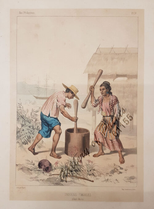
- View cart You cannot add another "Indiens Tagales pilant du riz [Tagal Indians pounding rice.]" to your cart.
- Sorry, this product cannot be purchased.
- You cannot add "The Image of the World. 20 Centuries of World Maps" to the cart because the product is out of stock.
- View cart You cannot add another "Atlas of Military History. An Illustrated Global Survey of Warfare from Antiquity to the Present Day" to your cart.
- View cart You cannot add another "El Sitio de Manila (1898). Memorias de un voluntario" to your cart.
- Sorry, this product cannot be purchased.
View cart “Girls Bathing” has been added to your cart.
View cart “Anchorages of Luzon, Mindoro and Marinduque. insets: 1) Luzon – West Coast. Bolinao Harbour. From the United States Government Survey of 1904. With additions and corrections from Philippine Gov’t. Charts to 1964. 2) Luzon – West Coast. Port Masinloc and Port Matalvi. From the United States Government Surveys of 1937. With additions and corrections from Philippine Gov’t. Charts to 1964. 3) Luzon – West Coast. Mariveles Harbour. From the United States Government Chart of 1940. With additions and corrections from Philippine Gov’t. Charts to 1964. 4) Luzon – South – West Coast. Batangas. From the Philippine Government Chart of 1956. With additions and corrections to 1964. 5) Luzon – South – West Coast. Nasugbu Bay. From the Philippine Government Chart of 1956. 6) Marinduque. Port Balanacan. From the United States Government Survey of 1908. With additions and corrections from Philippine Gov’t. Charts to 1964. 7) Marinduque. Santa Cruz Harbour. From the United States Government Survey of 1908. With additions and corrections from Philippine Gov’t. Charts to 1964. 8) Mindoro – North Coast. Port Galera and Varadero Bay. From the United States Government Surveys to 1939. With additions and corrections from Philippine Gov’t. Charts to 1964.” has been added to your cart.
View cart “[Luzon & Visayas]]” has been added to your cart.
View cart “Vue de Sambouangue [View of Zamboanga]” has been added to your cart.
View cart “Environs of Manila” has been added to your cart.
View cart “The Murillo Bulletin, Journal of PHIMCOS, Issue No. 13” has been added to your cart.
View cart “The Luneta, Manila” has been added to your cart.
View cart “Die Chinesen, Japaner und Inder auf den Philippinen [The Chinese, Japanese, and Indians in the Philippines]” has been added to your cart.
View cart “‘Philippines. Philippinen. – Trombe et Typhon. Wasserhose. (Typhoon) [per text: Philippines]” has been added to your cart.
View cart “Le Magasin Pittoresque” has been added to your cart.
View cart “Prout’s Microcosm Plate 11” has been added to your cart.
View cart “1. Embarquement des troupes pour Cuba, a Tampa 2. Depart du “Peking”, transportant des troupes a Manille” has been added to your cart.