Tel : +63(2)-7729-8168
|
Email Us : gallery@gop.com.ph
My Account
Remember Me
Register
64 Item(s)
-
₱
1,915,500.00
Salmon
1 x
₱
5,500.00
The Luneta, Manila
1 x
₱
3,300.00
Lettres édifiantes et curieuses, ecrites des Missions Etrangeres, par quelques Missionaires de la Compagnie de Jesus; Epitre du Halde, Lettres des…Bouchet (Inde), Taillandier), Relation …deconverte …nouvelles Philippines [pp. 75-91]…Dentrecolles, Jacquemin (Chine), Gabriel (illinois), Sepp (Paraguay)
1 x
₱
29,500.00
1. Carte de la baie de Manille. 2. Carte générale de îles Philippines. 3. Baie de Cavite. 4. Diagrame de forces respectives des eccadres américaine et espagnole au combat de Manille.
1 x
₱
6,600.00
Bamboo Signal Used by Natives in Marinduque
1 x
₱
3,300.00
1) Plan of Solsogon Harbour on the South Coast of Luconia. 2) Chart on the Eastern Coast of Bongo Bay in the Island of Mindanao.
1 x
₱
36,500.00
1) Le Pic de la Encenada. [The Peak of Encenada] 2) Le Pic Cardinal. [The Cardinal Peak] 3) Le Pic verd. [The Green Peak] 4) Le Pic verd de l'Isle de Luçon. [The Green Peak in the Island of Luzon]
1 x
₱
6,600.00
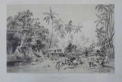
Environs de Samboangan (Ile Mindanao)
1 x
₱
33,900.00
Entrée de la baie de Manille, (Iles Philippines) Entrevue nocturne de l'Auteur avec les petits noirs des Montagnes. [Entrance of Manila Bay (Philippine Islands) Nocturnal Meeting of the Author With the Native Mountain People]
1 x
₱
298,000.00
Harper's Weekly - A Journal of Civilization with frontispiece: Ice-Yachting-Hard-A-Lee! Drawn by W. P. Snyder.
1 x
₱
7,700.00
A Plan of the Bay of Manila / A Plan of the Harbour of Acapulco / A View of 2 of the Ladrone Islands
1 x
₱
39,600.00
1. Pirogue de peche de la baie de Manille [Fishing canoe from Manila Bay] 2. Plan 3. Elevation de l'arriere [Rear Elevation] 4. Section 5. & 6. Avirons [Oars] 7. Petite pirogue [Small Canoe] 8. Plan 9. Elevation de l'arriere [Rear Elevation]
1 x
₱
50,600.00
Philippine Islands. Luzon Island. North of Latitude 16° 20' North. From the United States Cost Survey Charts to 1925. With additions and correctionsfrom the Philippine Gov't. Charts to 1963. Soundings in hairline enlarged from smaller scale charts.
1 x
₱
11,000.00
Chart of the Coast of China and of the Japan Islands including the Marianes and a part of the Philippines. Compiled by order of Commodore M. C. Perry. U.S.N. from the latest authorities with additions and corrections by the U.S. Japan Expedition by Lieuts. W. L. Maury and S. Bent. U.S.N.
1 x
₱
39,600.00
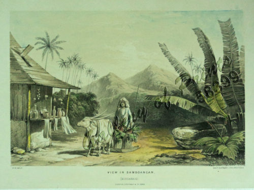
View in Samboangan. (Mindanao)
1 x
₱
17,200.00
Panay I. - Port Batan
1 x
₱
4,400.00
2) The Nabaloi Dialect 3) The Bataks of Palawan Ethnological Survey Publications vol. 2, parts 2 & 3
1 x
₱
9,900.00
A Map of the East Indies from the latest Authorities and Observations By John Blair L.L.D. & F.R.S. As a Supplement to His Tables of Chronology. [inset:] The Philippine Islands.
1 x
₱
26,400.00
Dr. A. Petermann's Mittheilungen aus Justus Perthes' Geographischer Anstalt. Herausgegeben von Prof. Dr. A. Supan. - Ergänzungsband XVII, 1884-1885 Inhalt: [Supplement Vol. 17 contents] No. 76. Regel, Entwickelung der Ortschaften im Thüringerwald. No. 77. Stolze und Andreas, die Handelsverhältnisse Persiens. No. 78. Fritsche, ein Beitrag zur Geographie und Lehre vom Erdmagnetismus Asiens und Europas. No. 79. Mohn, die Strömungen des europäischen Nordmeeres. No. 80. Boas, Baffin-Land.
1 x
₱
6,000.00
1. Plantain. (Banana Tree), 2. Papaw Leaf and Tree, 3. Cocoanut Palms
1 x
₱
2,200.00
Carte des Indes en deçà et au delà du Gange… et les Philippines
1 x
₱
6,600.00
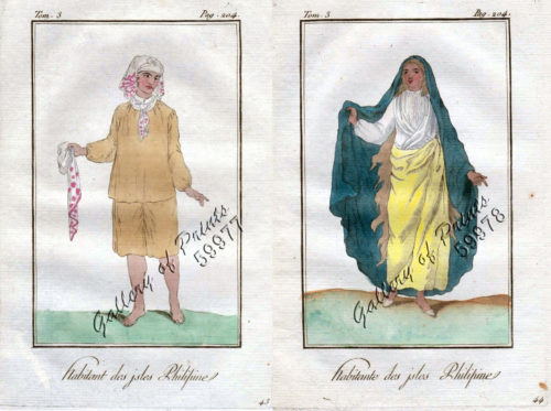
1) Habitant des Isles Philipine. 2) Femme des Isles Philipine [sic]
1 x
₱
18,700.00
[Cloudless Sulphur Butterfly and Caterpillar with Moth]
1 x
₱
6,600.00
Aux Îles Philippines. [Pictures from the Philippines]. 1) Le port de Manille. [Harbour of Manila]. 2) Un marché. [In the Market]. 3) La rue du rosaire a Manille. [Manila Street]. 4) Indigènes broyant du riz. [Natives Pounding Rice]. 5) Forge primitive dans un village. [Dwellings of Islanders with Smithy]. 6) Promenade en hamac. [In a Sedan]
1 x
₱
4,400.00
Philippine Islands. Sibuyan Sea to San Bernardino Strait. From the United States Government Charts to 1934.
1 x
₱
11,000.00
Lucon et Palaouan [Map of Luzon / Visayas]
1 x
₱
7,700.00
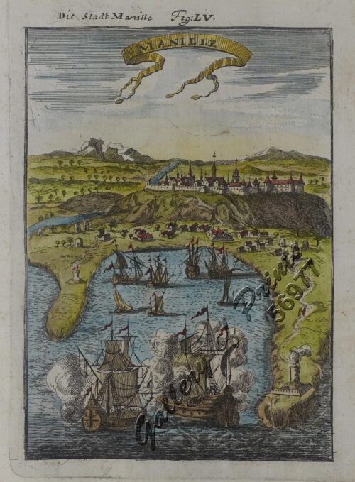
Manille - Die Stadt Manille
1 x
₱
25,500.00
The War in Manila: Late views from the Front 1. Third Regiment Heavy Artillery in Line of Battle at Caloocan 2. Signaling at Caloocan 3. United Staes Tenst under Bamboo Thickets 4. In the Burned District in Manila 5. Dead Filipinos in their Trenches at Sta. Ana, near Manila 6. Commissary's Tent at Caloocan
1 x
₱
4,400.00
Terrain Handbook 41 Manila (Philippine Series)
1 x
₱
22,000.00
1. Caboteur de la Laguna [Coaster from La Laguna] 2. Plan 3. Section Approchee d'un Bilallo de la riviere Passit [Enlarged section of a "Bilalo" from the river Pasig] 4. Tissu des Voiles [Fabric of the sails]
1 x
₱
49,600.00
The National Geographic Magazine, vol.XXIII, no. 9. Head-Hunters of Northern Luzon
1 x
₱
7,700.00
The Philippine Journal of Science D. General Biology, Ethnology, and Anthropoly New Species of Philippine Lizards The Eggs of Ascaris Lumbricoides Zur Staphylinidenfauna der Philippinen: … Dryopidae et Heteroceridae des Philippines… Notices of Certain
1 x
₱
2,200.00
Cavite (Islas Filipinas). - Carretera Real de Nagsubú [sic] [Nasugbu]
1 x
₱
3,300.00
a) bezeichnet den Lauf der Gallion Nuestra Señora de Cabadongo von Manila nach Acapulco.; b) Lauf der Gallion von Acapulco bis nach Guam, und von da nach den Philippinischen Inseln, wo diese Gallion am 30 Jun. 1743 von dem Ober Befehlshaber Anson erobert ward.
1 x
₱
26,400.00
The Earthquake at Manilla: 3 views. 1) Nave of the Cathedral after the Earthquake. 2) Tower of Binondo Church after the Earthquake. 3) Ruins of the Danish Consulate
1 x
₱
8,800.00
The Revolt in the Philippine Islands. 1. Philippine Aborigines. 2. View of the River Pasig at Manila. 3. Gate Leading Within the Walls. 4. Village of San Juento. 5. Types of the Native Soldiery.
1 x
₱
5,500.00
Rio Grande of Mindanao
1 x
₱
11,000.00
1. Cap Blanc sur la Cote des Patagons,… Kaap Blanco aan de kust van Patagonian… 2. Cap Blanc, restant au S.O. …. Kaap Blanco strekkende Zuid len ….
1 x
₱
4,400.00
Indischer Archipel Philippinischer Malaye nebst Frau. Uhreinwohner[sic] der Philippinen. [Philippine Malay with Wife. Natives of the Philippines.]
1 x
₱
5,500.00
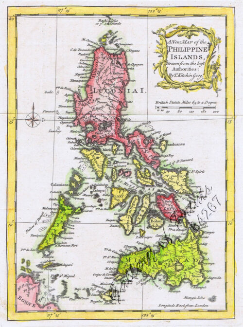
A New Map of the Philippine Islands, Drawn from the best Authorities
1 x
₱
77,000.00
A Plan of the Bay of Manila / A Plan of the Harbour of Acapulco / A View of 2 of the Ladrone Islands
1 x
₱
39,600.00
Ueber die Negritos oder Aetas der Philippinen. [Regarding the Negritos or Aetas of the Philippines]
1 x
₱
11,000.00
Archipiélago Filipino - Isla de Mindanao Plano del Puerto de Pollok
1 x
₱
4,400.00
1. Oriolus Vulneratus (female) [Black-and-crimson Oriole] 2. Prioniturus Cyaneiceps (female) [Blue Racket-Tailed Parakeet]
1 x
₱
13,200.00
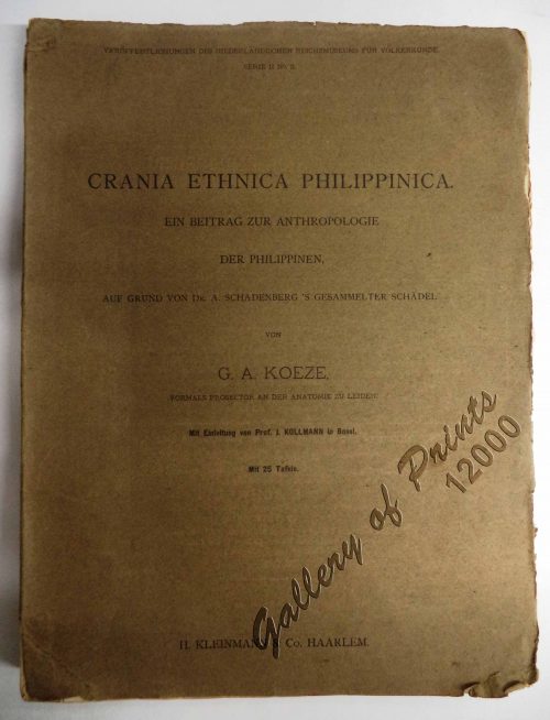
Crania Ethnica Philippinica. Ein Beitrag zur Anthropologie der Philippinen auf Grund von Dr. A. Schadenberg's gesammelter Scha[e]del [Dr. A. Schadenberrg's Collection of Skulls - Basis for a Controbution to Philippine Anthopology]
1 x
₱
13,200.00
A Boat Girl at Canton
1 x
₱
4,400.00
Plan of the Bay of Manilla in the Isle of Luconia, the Principal of the Philippine Islands, Surveyed by Señor Alexandro Malaspina and Communicated By Captn. G.G. Richardson.
1 x
₱
120,000.00
Carte d' Espagne et des principaux etats appartments a Cette Monarchie dans les Parties du Monde. 1. Isles Philipines. 2. Duche de Millan. 3. Royaume de Naples. 4. Royaume de Sicille. 5. Isles Antilles. 6. Nouveau Mexique. 7. Nouvelle Espagne. 8. Terre Ferme. 9. Le Perou. 10. Chili. 11. Rio de Plata ou Paraguay. 12. Pais Bas Catolique. 13. Isles de Sardaigne. 14. Isles Canaries ou Isles Fortunees. 15. Espagne.
1 x
₱
39,600.00
1) Isla de Paragua o Palawan Sur pl. 25 (Southern Palawan)
1 x
₱
7,700.00
[Carte Reduite] Carte Réduite des Isles Philippines Pour Servir Aux Vaisseaux du Roy Dressée au Dépost des Cartes Plans et Journaux de la Marine
1 x
₱
425,000.00
1) Parao, Bateau de Passage de Manille (Parao, ferryboat of Manila); 2) Sarambeau, Radeau de Peche de Manille (Sarambao, fish trap of Manila)
1 x
₱
22,000.00
New Volcano on Camiguin Island, Mindanao, Philippines. From a Sketch Taken on Board H.M.S. Challenger. [frontispiece]
1 x
₱
9,900.00
Arroyo sur la côte orientale de Mindanao [East Coast of Mindanao]
1 x
₱
4,400.00
Übersichtskarte der Franzosischen Expedition in Hinterindien vom Me-khong bis zum Jang-tse-kiang 1867-1868. Mit Benutzung einer Skizze von Garnier … [Map of the French Expedition …based on …Garnier]
1 x
₱
6,600.00
Mittheilungen aus Justus Perthes' Geographischer Anstalt über Wichtige neue Erforschungen auf dem Gesammtgebiete der Geographie von Dr. A. Petermann. - Ergänzungsband I, 1860 u. 1861. Inhalt: [Supplement Vol. 1 contents] No. 1. A. Vibe, Küsten and Meer Norwegens. No. 2. J. J. v. Tschudi, Reise durch die Andes von Sud- Amerika, 1858. No. 3. Dr. H. Barth, Reise durch Kleinasien, 1858. No. 4. G. Lejean, Ethnographie de Europäischen Türkei, mit französischem und deutschem Text. No. 5. Dr. Moritz Wagner, Physisch - geographische Skizze des Isthmus von Panama. No. 6. Petermann und Hassenstein, Ost - Afrika zwischen Chartum, Sauakin and Massaua.
1 x
₱
8,600.00
1) Plan du port d' Acapulco sur la Côte du Mexique dans la Mer du Sud. 2) Plan de la Baye de Manille
1 x
₱
26,400.00
Archipel de Jolo
1 x
₱
3,300.00
Stoparola Cerviniventris [Flycatcher] & Pericrocotus Cinereigula [Minivet]
1 x
₱
13,200.00
A Chart of the Channel in the Philipine Islands [sic] Through which the Manila Galeon passes, with a Map of Manila Island.
1 x
₱
26,400.00
Mapa de Filipinas, Joló y norte de Borneo
1 x
₱
7,700.00
Harper's New Monthly Magazine
1 x
₱
7,700.00
Anona Squamosa. L. [English: Sweetsop. Tagalog: Atis]
1 x
₱
49,500.00
La Buyera.
1 x
₱
49,500.00
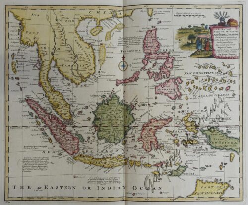
A New and Accurate Map of the East India Islands
1 x
₱
56,100.00
View Cart
Checkout
Home
About Us
Publications
Shop Online
Framing Services
Exhibits
Picture Hanging System
Contact Us
View cart
You cannot add another "[Cloudless Sulphur Butterfly and Caterpillar with Moth]" to your cart.
View cart
“A New and Accurate Map of the East India Islands” has been added to your cart.
Sort by
Date
Sort by
Default Order
Sort by
Name
Sort by
Price
Sort by
Date
Sort by
Popularity
Show
30 Products
Show
30 Products
Show
60 Products
Show
90 Products
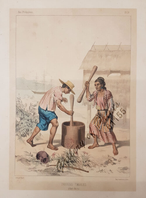
Indiens Tagales pilant du riz [Tagal Indians pounding rice.]...
₱
61,600.00
Add to cart
Details
1. Panguingui (Card-playing) in Manilla; 2. Planting Rice in...
₱
7,700.00
Add to cart
Details
Sketches in Manilla. 1. Chinese Chow-chow sellers at Manilla...
₱
7,700.00
Add to cart
Details
Palais du Sultan de Soulou… [Palace of the Sultan of Sulu]...
₱
13,200.00
Add to cart
Details
Eene audiente bij den Sultan van Soeloe
₱
11,000.00
Add to cart
Details
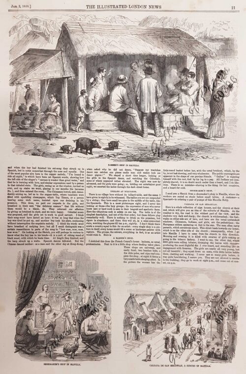
Sketches in Manilla. 1. Barber’s shop in Manilla; 2. S...
₱
7,700.00
Add to cart
Details
Tahiti Girl Gathering Oranges.
₱
4,400.00
Add to cart
Details
A Boat Girl at Canton
₱
4,400.00
Add to cart
Details
Japanese Page
₱
4,400.00
Add to cart
Details
The Earthquake at Manilla: 3 views. 1) Nave of the Cathedral...
₱
8,800.00
Add to cart
Details
The Trouble in the Philippines: American Troops Entering San...
₱
7,700.00
Add to cart
Details
Pêcheurs dans riviere de Passit. [Fishermen on The Pasig Ri...
₱
39,600.00
Add to cart
Details
New York- A Suggestion For the Improvement of the Hudson Riv...
₱
5,500.00
Add to cart
Details
Aux Îles Philippines. [Pictures from the Philippines]. 1) L...
₱
4,400.00
Add to cart
Details
Planting Rice in Manilla
₱
6,600.00
Add to cart
Details
[Boy and Girl Sewing] Manila
₱
3,300.00
Add to cart
Details
La Danese [The Danish]
₱
6,600.00
Add to cart
Details
[Emperor Moth]
₱
6,600.00
Add to cart
Details
[Cloudless Sulphur Butterfly and Caterpillar with Moth]
₱
6,600.00
Add to cart
Details
Salmon
₱
5,500.00
Add to cart
Details
Pike and Perch
₱
5,500.00
Add to cart
Details
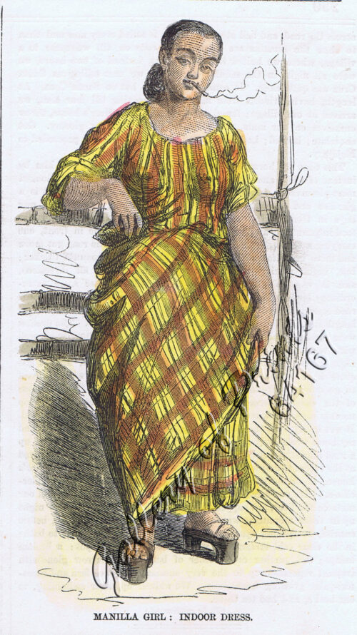
Manilla Girl: Indoor Dress.
₱
4,400.00
Add to cart
Details
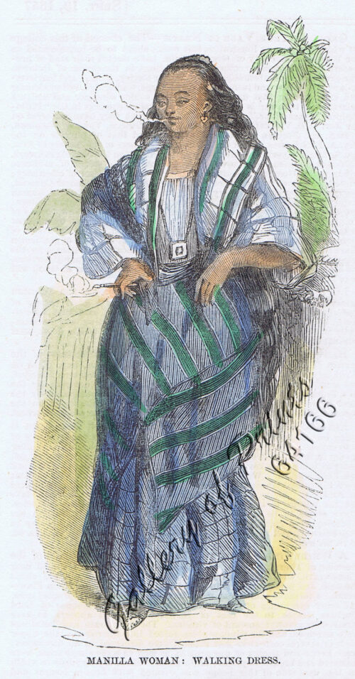
Manilla Woman: Walking Dress.
₱
4,400.00
Add to cart
Details
Pont de Manille (Iles Philippines.) [Manila Bridge (Philipp...
₱
330,000.00
Add to cart
Details
El indio viejo [The Old Indio]
₱
49,500.00
Add to cart
Details
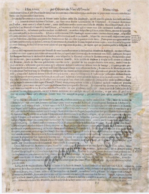
Ladmiral surmonte s’en allant au fond a nostre veúe
₱
49,600.00
Add to cart
Details
Entrée de la baie de Manille, (Iles Philippines) Entrevue n...
₱
298,000.00
Add to cart
Details
Schlacht for Manille [Battle for Manila] ( Oliver van Noor...
₱
49,500.00
Add to cart
Details
New Volcano on Camiguin Island, Mindanao, Philippines. From ...
₱
9,900.00
Add to cart
Details
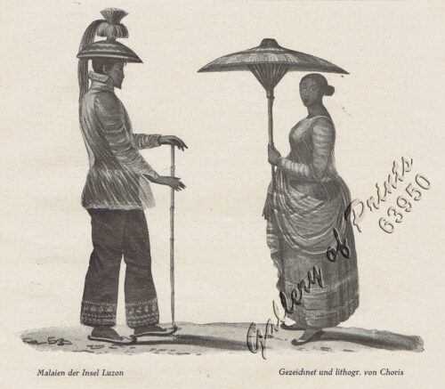
Malaien der Insel Luzon [Malay of Luzon Island]
₱
6,600.00
Add to cart
Details
Previous
1
2
3
4
5
…
13
14
15
Next
Shopping Cart
A New and Accurate Map of the East India Islands
1
La Buyera.
1
Anona Squamosa. L. [English: Sweetsop. Tagalog: Atis]
1
Harper's New Monthly Magazine
1
Mapa de Filipinas, Joló y norte de Borneo
1
A Chart of the Channel in the Philipine Islands [sic] Through which the Manila Galeon passes, with a Map of Manila Island.
1
Stoparola Cerviniventris [Flycatcher] & Pericrocotus Cinereigula [Minivet]
1
Archipel de Jolo
1
1) Plan du port d' Acapulco sur la Côte du Mexique dans la Mer du Sud. 2) Plan de la Baye de Manille
1
Mittheilungen aus Justus Perthes' Geographischer Anstalt über Wichtige neue Erforschungen auf dem Gesammtgebiete der Geographie von Dr. A. Petermann. - Ergänzungsband I, 1860 u. 1861. Inhalt: [Supplement Vol. 1 contents] No. 1. A. Vibe, Küsten and Meer Norwegens. No. 2. J. J. v. Tschudi, Reise durch die Andes von Sud- Amerika, 1858. No. 3. Dr. H. Barth, Reise durch Kleinasien, 1858. No. 4. G. Lejean, Ethnographie de Europäischen Türkei, mit französischem und deutschem Text. No. 5. Dr. Moritz Wagner, Physisch - geographische Skizze des Isthmus von Panama. No. 6. Petermann und Hassenstein, Ost - Afrika zwischen Chartum, Sauakin and Massaua.
1
Übersichtskarte der Franzosischen Expedition in Hinterindien vom Me-khong bis zum Jang-tse-kiang 1867-1868. Mit Benutzung einer Skizze von Garnier … [Map of the French Expedition …based on …Garnier]
1
Arroyo sur la côte orientale de Mindanao [East Coast of Mindanao]
1
New Volcano on Camiguin Island, Mindanao, Philippines. From a Sketch Taken on Board H.M.S. Challenger. [frontispiece]
1
1) Parao, Bateau de Passage de Manille (Parao, ferryboat of Manila); 2) Sarambeau, Radeau de Peche de Manille (Sarambao, fish trap of Manila)
1
[Carte Reduite] Carte Réduite des Isles Philippines Pour Servir Aux Vaisseaux du Roy Dressée au Dépost des Cartes Plans et Journaux de la Marine
1
1) Isla de Paragua o Palawan Sur pl. 25 (Southern Palawan)
1
Carte d' Espagne et des principaux etats appartments a Cette Monarchie dans les Parties du Monde. 1. Isles Philipines. 2. Duche de Millan. 3. Royaume de Naples. 4. Royaume de Sicille. 5. Isles Antilles. 6. Nouveau Mexique. 7. Nouvelle Espagne. 8. Terre Ferme. 9. Le Perou. 10. Chili. 11. Rio de Plata ou Paraguay. 12. Pais Bas Catolique. 13. Isles de Sardaigne. 14. Isles Canaries ou Isles Fortunees. 15. Espagne.
1
Plan of the Bay of Manilla in the Isle of Luconia, the Principal of the Philippine Islands, Surveyed by Señor Alexandro Malaspina and Communicated By Captn. G.G. Richardson.
1
A Boat Girl at Canton
1
Crania Ethnica Philippinica. Ein Beitrag zur Anthropologie der Philippinen auf Grund von Dr. A. Schadenberg's gesammelter Scha[e]del [Dr. A. Schadenberrg's Collection of Skulls - Basis for a Controbution to Philippine Anthopology]
1
1. Oriolus Vulneratus (female) [Black-and-crimson Oriole] 2. Prioniturus Cyaneiceps (female) [Blue Racket-Tailed Parakeet]
1
Archipiélago Filipino - Isla de Mindanao Plano del Puerto de Pollok
1
Ueber die Negritos oder Aetas der Philippinen. [Regarding the Negritos or Aetas of the Philippines]
1
A Plan of the Bay of Manila / A Plan of the Harbour of Acapulco / A View of 2 of the Ladrone Islands
1
A New Map of the Philippine Islands, Drawn from the best Authorities
1
Indischer Archipel Philippinischer Malaye nebst Frau. Uhreinwohner[sic] der Philippinen. [Philippine Malay with Wife. Natives of the Philippines.]
1
1. Cap Blanc sur la Cote des Patagons,… Kaap Blanco aan de kust van Patagonian… 2. Cap Blanc, restant au S.O. …. Kaap Blanco strekkende Zuid len ….
1
Rio Grande of Mindanao
1
The Revolt in the Philippine Islands. 1. Philippine Aborigines. 2. View of the River Pasig at Manila. 3. Gate Leading Within the Walls. 4. Village of San Juento. 5. Types of the Native Soldiery.
1
The Earthquake at Manilla: 3 views. 1) Nave of the Cathedral after the Earthquake. 2) Tower of Binondo Church after the Earthquake. 3) Ruins of the Danish Consulate
1
a) bezeichnet den Lauf der Gallion Nuestra Señora de Cabadongo von Manila nach Acapulco.; b) Lauf der Gallion von Acapulco bis nach Guam, und von da nach den Philippinischen Inseln, wo diese Gallion am 30 Jun. 1743 von dem Ober Befehlshaber Anson erobert ward.
1
Cavite (Islas Filipinas). - Carretera Real de Nagsubú [sic] [Nasugbu]
1
The Philippine Journal of Science D. General Biology, Ethnology, and Anthropoly New Species of Philippine Lizards The Eggs of Ascaris Lumbricoides Zur Staphylinidenfauna der Philippinen: … Dryopidae et Heteroceridae des Philippines… Notices of Certain
1
The National Geographic Magazine, vol.XXIII, no. 9. Head-Hunters of Northern Luzon
1
1. Caboteur de la Laguna [Coaster from La Laguna] 2. Plan 3. Section Approchee d'un Bilallo de la riviere Passit [Enlarged section of a "Bilalo" from the river Pasig] 4. Tissu des Voiles [Fabric of the sails]
1
Terrain Handbook 41 Manila (Philippine Series)
1
The War in Manila: Late views from the Front 1. Third Regiment Heavy Artillery in Line of Battle at Caloocan 2. Signaling at Caloocan 3. United Staes Tenst under Bamboo Thickets 4. In the Burned District in Manila 5. Dead Filipinos in their Trenches at Sta. Ana, near Manila 6. Commissary's Tent at Caloocan
1
Manille - Die Stadt Manille
1
Lucon et Palaouan [Map of Luzon / Visayas]
1
Philippine Islands. Sibuyan Sea to San Bernardino Strait. From the United States Government Charts to 1934.
1
Aux Îles Philippines. [Pictures from the Philippines]. 1) Le port de Manille. [Harbour of Manila]. 2) Un marché. [In the Market]. 3) La rue du rosaire a Manille. [Manila Street]. 4) Indigènes broyant du riz. [Natives Pounding Rice]. 5) Forge primitive dans un village. [Dwellings of Islanders with Smithy]. 6) Promenade en hamac. [In a Sedan]
1
[Cloudless Sulphur Butterfly and Caterpillar with Moth]
1
1) Habitant des Isles Philipine. 2) Femme des Isles Philipine [sic]
1
Carte des Indes en deçà et au delà du Gange… et les Philippines
1
1. Plantain. (Banana Tree), 2. Papaw Leaf and Tree, 3. Cocoanut Palms
1
Dr. A. Petermann's Mittheilungen aus Justus Perthes' Geographischer Anstalt. Herausgegeben von Prof. Dr. A. Supan. - Ergänzungsband XVII, 1884-1885 Inhalt: [Supplement Vol. 17 contents] No. 76. Regel, Entwickelung der Ortschaften im Thüringerwald. No. 77. Stolze und Andreas, die Handelsverhältnisse Persiens. No. 78. Fritsche, ein Beitrag zur Geographie und Lehre vom Erdmagnetismus Asiens und Europas. No. 79. Mohn, die Strömungen des europäischen Nordmeeres. No. 80. Boas, Baffin-Land.
1
A Map of the East Indies from the latest Authorities and Observations By John Blair L.L.D. & F.R.S. As a Supplement to His Tables of Chronology. [inset:] The Philippine Islands.
1
2) The Nabaloi Dialect 3) The Bataks of Palawan Ethnological Survey Publications vol. 2, parts 2 & 3
1
Panay I. - Port Batan
1
View in Samboangan. (Mindanao)
1
Chart of the Coast of China and of the Japan Islands including the Marianes and a part of the Philippines. Compiled by order of Commodore M. C. Perry. U.S.N. from the latest authorities with additions and corrections by the U.S. Japan Expedition by Lieuts. W. L. Maury and S. Bent. U.S.N.
1
Philippine Islands. Luzon Island. North of Latitude 16° 20' North. From the United States Cost Survey Charts to 1925. With additions and correctionsfrom the Philippine Gov't. Charts to 1963. Soundings in hairline enlarged from smaller scale charts.
1
1. Pirogue de peche de la baie de Manille [Fishing canoe from Manila Bay] 2. Plan 3. Elevation de l'arriere [Rear Elevation] 4. Section 5. & 6. Avirons [Oars] 7. Petite pirogue [Small Canoe] 8. Plan 9. Elevation de l'arriere [Rear Elevation]
1
A Plan of the Bay of Manila / A Plan of the Harbour of Acapulco / A View of 2 of the Ladrone Islands
1
Harper's Weekly - A Journal of Civilization with frontispiece: Ice-Yachting-Hard-A-Lee! Drawn by W. P. Snyder.
1
Entrée de la baie de Manille, (Iles Philippines) Entrevue nocturne de l'Auteur avec les petits noirs des Montagnes. [Entrance of Manila Bay (Philippine Islands) Nocturnal Meeting of the Author With the Native Mountain People]
1
Environs de Samboangan (Ile Mindanao)
1
1) Le Pic de la Encenada. [The Peak of Encenada] 2) Le Pic Cardinal. [The Cardinal Peak] 3) Le Pic verd. [The Green Peak] 4) Le Pic verd de l'Isle de Luçon. [The Green Peak in the Island of Luzon]
1
1) Plan of Solsogon Harbour on the South Coast of Luconia. 2) Chart on the Eastern Coast of Bongo Bay in the Island of Mindanao.
1
Bamboo Signal Used by Natives in Marinduque
1
1. Carte de la baie de Manille. 2. Carte générale de îles Philippines. 3. Baie de Cavite. 4. Diagrame de forces respectives des eccadres américaine et espagnole au combat de Manille.
1
Lettres édifiantes et curieuses, ecrites des Missions Etrangeres, par quelques Missionaires de la Compagnie de Jesus; Epitre du Halde, Lettres des…Bouchet (Inde), Taillandier), Relation …deconverte …nouvelles Philippines [pp. 75-91]…Dentrecolles, Jacquemin (Chine), Gabriel (illinois), Sepp (Paraguay)
1
The Luneta, Manila
1
Salmon
1
Cart
Checkout
Continue Shopping
64