- View cart You cannot add another "Danse du mariage chez les Négritos (voy. p. 110) [Marriage Dance of the Negritoes]" to your cart.
- View cart You cannot add another "Lost at Sea. The strange route of the Lena Shoal junk" to your cart.
- View cart You cannot add another "El indio viejo [The Old Indio]" to your cart.
View cart “Le Combat Naval Devant Manille 1. Le <>, croiseur américain de 1re classe. 2. Le <>, croiseur américain de 2e classe.” has been added to your cart.
View cart “Bahia de Manila” has been added to your cart.
View cart “Carte Hydrographique & Chorographique des Isles Philippines Carta Hydrographica y Chorographica de las Ysles Filipinas” has been added to your cart.
View cart “En el archipiélago de la Especiería España y Molucas en los siglos XVI y XVII [In the Spanish Spice Archipelago and Moluccas in the 16th and 17th Centuries]” has been added to your cart.
View cart “Ports in the Philippine Islands. insets: 1) Luzon I. – West Coast. Manila and Cavite Anchorages. From the United States Government Chart of 1950. with additions and corrections to 1969. 2) Luzon I. – West Coast. Manila Harbour. From the United States Government Chart of 1950. with additions and corrections to 1969.” has been added to your cart.
View cart “The Murillo Bulletin, Journal of PHIMCOS, Issue No. 13” has been added to your cart.
View cart “Philippine Islands. Anchorages in Northern Luzon and the Babuyan Islands. Insets: 1) Babuyan Is. – Fuga I. Musa Bay. From the United States Government Chart to 1931. 2) Babuyan Is. – Camiguin I. Port San Pio Quinto. From the United States Government Chart to 1931. 3) Luzon-North-East Coast Port San Vicente. From the United States Government Chart to 1938. 4) Luzon – East Coast Mauban Anchorage. From the Philippine Government Chart of 1957. 5) Luzon – West Coast. Salomague Harbour and Lapog Bay. From the United States Government Chart of 1934. 6) Luzon – West Coast Port Currimao and Gan Bay. From the United States Government Chart of 1934. 7) Luzon – West Coast Solvec Cove. From the United States Government Chart of 1934. 8) Luzon – West Coast Lingayen Gulf. Port Sual with Cabalitian Bay. From the United States Government Chart of 1922. 9) Luzon – West Coast San Fernando Harbour. From the United States Government Chart of 1936.” has been added to your cart.
View cart “Der Vulkan von Taal auf Luzon” has been added to your cart.
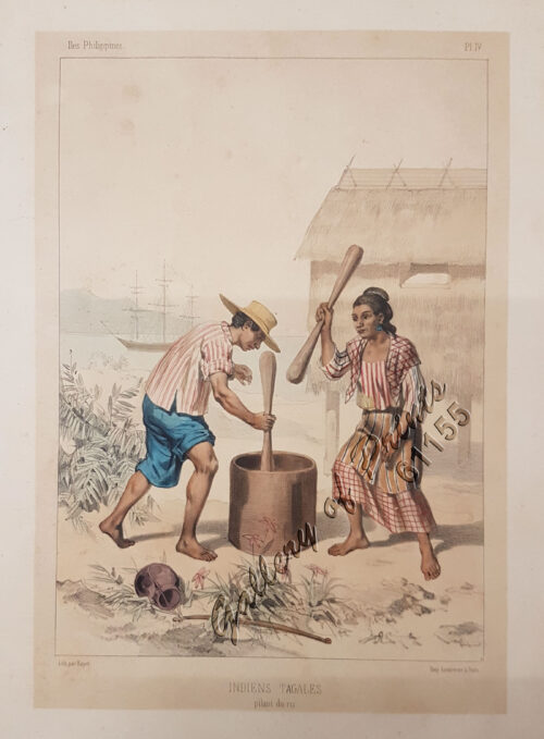
View cart “Indiens Tagales pilant du riz [Tagal Indians pounding rice.]” has been added to your cart.
View cart “Germany, the Philippines, and the Spanish American War.” has been added to your cart.
View cart “The Philippines in Ancient Chinese Maps” has been added to your cart.
View cart “El Galeón del Pacífico Manila Acapulco-Manila 1565-1815” has been added to your cart.