Tel : +63(2)-7729-8168
|
Email Us : gallery@gop.com.ph
My Account
Remember Me
Register
30 Item(s)
-
₱
3,417,100.00
The Bontoc Igorot. The Ethnological Survey Publications vol. 1.
1 x
₱
14,700.00
Waterfall of the Botocan (Laguna, Luzon)
1 x
₱
2,200.00
Manila (Filipinas) - Cuartel de la Guardia Civil Veterana en la Ermita.
1 x
₱
2,200.00
Embarcaciones Antiguas [Old Boats] 1. Tronco labrado en forma de canoa. [Trunk carved in the shape of a canoe]. 2. Embarcación de mimbres recubierta de cuero. [Wicker boat covered in leather]. 3. Barco de cuero. [Leather Boat]. 4. Nave romana. [Roman ship]. 5 y 6. Galera y galeaza del siglo XVI. [Galley and galleass from the 16th century]. 7. Galeón del siglo XVII. [17th century galleon.].
1 x
₱
7,700.00
Sammlung gemeinverständlicher wissenschaftlicher Vorträge [Collection of Scientific Presentations in a Generally Comprehensible Version] [INCLUDING:] Die Philippinen. Eine übersichtliche Darstellung der ethnographischen und historisch=politischen Verhältnisse des Archipels. [An Overview of the Ethnographic and Historical-Political Situation in the Archipelago] Mit einem Anhange - Die wichtigsten Paragraphen der Verfassung der philippinischen Republik. [The most important paragraphs of the Constitution of the Philippine Republic]
1 x
₱
15,700.00
Isla de Paragua o Palawan Sur pl. 25 (Southern Palawan)
1 x
₱
6,600.00
A Chart of the China Sea, and Philippine Islands, with the Archipelagos of Felicia and Sooloo, shewing… …Canton and Balambangan,… composed from an original drawing, communicated by Capt. Robert Carr. and compared with the map of Pedro Murillo de Velarde, engraved at Manilla in 1734…. insets: 1) The Ports of Ylocos, on the West Coast of Luzon. 2) The Bay of Subic, on the West Coast of Luzon.
1 x
₱
780,000.00
En el archipiélago de la Especiería España y Molucas en los siglos XVI y XVII [In the Spanish Spice Archipelago and Moluccas in the 16th and 17th Centuries]
1 x
₱
4,900.00
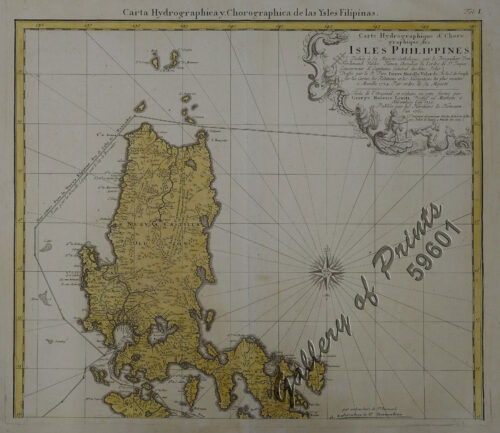
Carte Hydrographique & Chorographique des Isles Philippines (Carta Hydrographica y Chorographica de las Ysles Filipinas)
1 x
₱
425,000.00
Location of Troops in the Philippine Islands March 31, 1900.
1 x
₱
16,500.00
Carayas ou machines a pecher et Banka de Manille. ["Tarayas" (correctly called "Salambas") or fishing contraptions; and "Banka" from Manila]
1 x
₱
99,000.00
Der stille Ocean und die spanischen Besitzungen im ostindischen Archipel [The Pacific Ocean and the Spanish Colonies in the East Indian Archipelago]
1 x
₱
4,200.00
New York- A Suggestion For the Improvement of the Hudson River Water-front presented before the Architectural League by Milton See Drawn by HM. Pettit from the architect's plans - [see Page 241]
1 x
₱
3,300.00
1) Plan du port d' Acapulco sur la Côte du Mexique dans la Mer du Sud. 2) Plan de la Baye de Manille
1 x
₱
26,400.00
The Illustrated London News Vol. 36 - No. 1015
1 x
₱
6,600.00
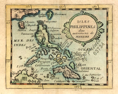
Isles Philippines dites autrement de Manilhe
1 x
₱
49,500.00
Map of the United States showing the Territorial Expansion of a Century 1804 to 1904 insets: 1) The World. 2) Wake Island. 3) Territory of Alaska. 4) Guam Island. 5) Porto Rico. 6) Philippine Islands. 7) Hawaiian Islands. 8) Tutuila, Manua and Smaller Islands of the Samoan Group. 9) Plan of Panama Canal Zone. 10) Plan showing the Thirteen Original States.
1 x
₱
33,100.00
1. State of the Philippines in 1810; 2. Philippine Progress Prior to 1898
1 x
₱
4,400.00
Chart of the Coast of China and of the Japan Islands including the Marianes and a part of the Philippines. Compiled by order of Commodore M. C. Perry. U.S.N. from the latest authorities with additions and corrections by the U.S. Japan Expedition by Lieuts. W. L. Maury and S. Bent. U.S.N.
1 x
₱
39,600.00
'Philippines. Philippinen. - Trombe et Typhon. Wasserhose. (Typhoon) [per text: Philippines]
1 x
₱
2,200.00
Die Ostindischen Inseln...
1 x
₱
39,600.00
Cascos de la Laguna, a la voile. ["Cascos" from La Laguna, under Sail]
1 x
₱
99,000.00
Rivière Sagaliud, Golfe de Sandakan
1 x
₱
3,300.00
All Over the Map. A Cartographic Odyssey
1 x
₱
5,800.00
Chart of Port IloIlo and Panay
1 x
₱
4,400.00
Nachrichten von den Pelew-Inseln -in der Westgegend des Stillen Ozeans [An Account of the Pelew Islands, Situated in the Western Part of the Pacific Ocean]
1 x
₱
2,200.00
[Carte Reduite] Carte Réduite des Isles Philippines Pour Servir Aux Vaisseaux du Roy Dressée au Dépost des Cartes Plans et Journaux de la Marine
1 x
₱
425,000.00
City of Manilla
1 x
₱
4,400.00
Insulae Philippinae… [inset: Manila]
1 x
₱
1,250,000.00
Cochinchine - Philippines 1. Femmes Cochinchinoises. 2. Tagals
1 x
₱
39,600.00
View Cart
Checkout
Home
About Us
Publications
Shop Online
Framing Services
Exhibits
Picture Hanging System
Contact Us
View cart
You cannot add another "Location of Troops in the Philippine Islands March 31, 1900." to your cart.
View cart
You cannot add another "Insulae Philippinae… [inset: Manila]" to your cart.
View cart
“Insulae Philippinae… [inset: Manila]” has been added to your cart.
View cart
“Cochinchine – Philippines 1. Femmes Cochinchinoises. 2. Tagals” has been added to your cart.
Sort by
Name
Sort by
Default Order
Sort by
Name
Sort by
Price
Sort by
Date
Sort by
Popularity
Show
30 Products
Show
30 Products
Show
60 Products
Show
90 Products
Begräbniβ [Funeral]
₱
2,200.00
Add to cart
Details
Bilalo, bateau de passage de Manille a Cavite. [Manila-Cavit...
₱
110,000.00
Add to cart
Details
Bilder von den Philippinen [Pictures of the Philippines] 1) ...
₱
4,400.00
Add to cart
Details
Bincungan, village moro.
₱
4,400.00
Add to cart
Details
Bird’s-eye View of Cavite, Showing the Arsenal, Fortif...
₱
20,900.00
Add to cart
Details
Bird’s-eye view of Manilla, Luzon, Philippine Islands....
₱
4,400.00
Add to cart
Details
Bird’s-eye view of Manilla, Luzon, Philippine Islands....
₱
7,700.00
Add to cart
Details
Bridge built of bamboo, province of Albay, Luzon.
₱
2,200.00
Add to cart
Details
Brug over de rio Tagulaya [Bamboo Bridge over Tagulaya River...
₱
4,400.00
Add to cart
Details
Caboteur et Pirogues de la Laguna pres de Manille. [Coasters...
₱
99,000.00
Add to cart
Details
Cadavres des juramentados réunis après l’attaque
₱
6,600.00
Add to cart
Details
Campagnard Tagal, pres de Manille (Iles Philippines.) [Taga...
₱
290,000.00
Add to cart
Details
Campagne des Environs de Manille (Oceanie) [Countryside near...
₱
8,800.00
Add to cart
Details
Campagne des Environs de Manille (Oceanie) [Countryside near...
₱
9,900.00
Add to cart
Details
Carayas ou machines a pecher et Banka de Manille. [“Ta...
₱
99,000.00
Add to cart
Details
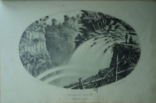
Cascada del Botocan. Provincia de la Laguna. [Botocan Falls]...
₱
49,500.00
Add to cart
Details
Cascos de la Laguna, a la voile. [“Cascos” from...
₱
99,000.00
Add to cart
Details
Cavite (Islas Filipinas). – Carretera Real de Nagsubú...
₱
3,300.00
Add to cart
Details
Cavite (Islas Filipinas). – La Calle del Arsenal.
₱
6,600.00
Add to cart
Details
Chart of Zamboanga
₱
4,400.00
Add to cart
Details
Chinese Vessels
₱
6,600.00
Add to cart
Details
Church and Square at Malolos
₱
5,500.00
Add to cart
Details
Church of Binondo, Manila
₱
6,600.00
Add to cart
Details
Chute d’Eau a Hala-Hala [Waterfalls at Jala-Jala]
₱
39,600.00
Add to cart
Details
City of Manilla
₱
6,600.00
Add to cart
Details
City of Manilla
₱
4,400.00
Add to cart
Details
Coaconut Plantation, Zambooanga, Philippine Islands.
₱
4,400.00
Add to cart
Details
Cochinchine – Philippines 1. Femmes Cochinchinoises. 2...
₱
39,600.00
Add to cart
Details
Cochini Rex elephante vectus, cum procerum comitatu, quos N...
₱
26,400.00
Add to cart
Details
Previous
1
2
3
4
5
6
…
13
14
15
Next
Shopping Cart
Cochinchine - Philippines 1. Femmes Cochinchinoises. 2. Tagals
1
Insulae Philippinae… [inset: Manila]
1
City of Manilla
1
[Carte Reduite] Carte Réduite des Isles Philippines Pour Servir Aux Vaisseaux du Roy Dressée au Dépost des Cartes Plans et Journaux de la Marine
1
Nachrichten von den Pelew-Inseln -in der Westgegend des Stillen Ozeans [An Account of the Pelew Islands, Situated in the Western Part of the Pacific Ocean]
1
Chart of Port IloIlo and Panay
1
All Over the Map. A Cartographic Odyssey
1
Rivière Sagaliud, Golfe de Sandakan
1
Cascos de la Laguna, a la voile. ["Cascos" from La Laguna, under Sail]
1
Die Ostindischen Inseln...
1
'Philippines. Philippinen. - Trombe et Typhon. Wasserhose. (Typhoon) [per text: Philippines]
1
Chart of the Coast of China and of the Japan Islands including the Marianes and a part of the Philippines. Compiled by order of Commodore M. C. Perry. U.S.N. from the latest authorities with additions and corrections by the U.S. Japan Expedition by Lieuts. W. L. Maury and S. Bent. U.S.N.
1
1. State of the Philippines in 1810; 2. Philippine Progress Prior to 1898
1
Map of the United States showing the Territorial Expansion of a Century 1804 to 1904 insets: 1) The World. 2) Wake Island. 3) Territory of Alaska. 4) Guam Island. 5) Porto Rico. 6) Philippine Islands. 7) Hawaiian Islands. 8) Tutuila, Manua and Smaller Islands of the Samoan Group. 9) Plan of Panama Canal Zone. 10) Plan showing the Thirteen Original States.
1
Isles Philippines dites autrement de Manilhe
1
The Illustrated London News Vol. 36 - No. 1015
1
1) Plan du port d' Acapulco sur la Côte du Mexique dans la Mer du Sud. 2) Plan de la Baye de Manille
1
New York- A Suggestion For the Improvement of the Hudson River Water-front presented before the Architectural League by Milton See Drawn by HM. Pettit from the architect's plans - [see Page 241]
1
Der stille Ocean und die spanischen Besitzungen im ostindischen Archipel [The Pacific Ocean and the Spanish Colonies in the East Indian Archipelago]
1
Carayas ou machines a pecher et Banka de Manille. ["Tarayas" (correctly called "Salambas") or fishing contraptions; and "Banka" from Manila]
1
Location of Troops in the Philippine Islands March 31, 1900.
1
Carte Hydrographique & Chorographique des Isles Philippines (Carta Hydrographica y Chorographica de las Ysles Filipinas)
1
En el archipiélago de la Especiería España y Molucas en los siglos XVI y XVII [In the Spanish Spice Archipelago and Moluccas in the 16th and 17th Centuries]
1
A Chart of the China Sea, and Philippine Islands, with the Archipelagos of Felicia and Sooloo, shewing… …Canton and Balambangan,… composed from an original drawing, communicated by Capt. Robert Carr. and compared with the map of Pedro Murillo de Velarde, engraved at Manilla in 1734…. insets: 1) The Ports of Ylocos, on the West Coast of Luzon. 2) The Bay of Subic, on the West Coast of Luzon.
1
Isla de Paragua o Palawan Sur pl. 25 (Southern Palawan)
1
Sammlung gemeinverständlicher wissenschaftlicher Vorträge [Collection of Scientific Presentations in a Generally Comprehensible Version] [INCLUDING:] Die Philippinen. Eine übersichtliche Darstellung der ethnographischen und historisch=politischen Verhältnisse des Archipels. [An Overview of the Ethnographic and Historical-Political Situation in the Archipelago] Mit einem Anhange - Die wichtigsten Paragraphen der Verfassung der philippinischen Republik. [The most important paragraphs of the Constitution of the Philippine Republic]
1
Embarcaciones Antiguas [Old Boats] 1. Tronco labrado en forma de canoa. [Trunk carved in the shape of a canoe]. 2. Embarcación de mimbres recubierta de cuero. [Wicker boat covered in leather]. 3. Barco de cuero. [Leather Boat]. 4. Nave romana. [Roman ship]. 5 y 6. Galera y galeaza del siglo XVI. [Galley and galleass from the 16th century]. 7. Galeón del siglo XVII. [17th century galleon.].
1
Manila (Filipinas) - Cuartel de la Guardia Civil Veterana en la Ermita.
1
Waterfall of the Botocan (Laguna, Luzon)
1
The Bontoc Igorot. The Ethnological Survey Publications vol. 1.
1
Cart
Checkout
Continue Shopping
30