View cart “Übersichtskarte der Franzosischen Expedition in Hinterindien vom Me-khong bis zum Jang-tse-kiang 1867-1868. Mit Benutzung einer Skizze von Garnier … [Map of the French Expedition …based on …Garnier]” has been added to your cart.
View cart “Cascos de la Laguna, a la voile. [“Cascos” from La Laguna, under Sail]” has been added to your cart.
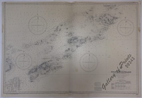
View cart “Philippine Islands. Anchorages in Northern Luzon and the Babuyan Islands. Insets: 1) Babuyan Is. – Fuga I. Musa Bay. From the United States Government Chart to 1931. 2) Babuyan Is. – Camiguin I. Port San Pio Quinto. From the United States Government Chart to 1931. 3) Luzon-North-East Coast Port San Vicente. From the United States Government Chart to 1938. 4) Luzon – East Coast Mauban Anchorage. From the Philippine Government Chart of 1957. 5) Luzon – West Coast. Salomague Harbour and Lapog Bay. From the United States Government Chart of 1934. 6) Luzon – West Coast Port Currimao and Gan Bay. From the United States Government Chart of 1934. 7) Luzon – West Coast Solvec Cove. From the United States Government Chart of 1934. 8) Luzon – West Coast Lingayen Gulf. Port Sual with Cabalitian Bay. From the United States Government Chart of 1922. 9) Luzon – West Coast San Fernando Harbour. From the United States Government Chart of 1936.” has been added to your cart.
View cart “Diez y Seis Años de Regencia (Maria Cristina de Hapsburgo-Lorena) [sic] (1885-1902) [Sixteen Years of Regency of Maria …]” has been added to your cart.
View cart “Port et Rade de Manille (Philippines)” has been added to your cart.