Tel : +63(2)-7729-8168
|
Email Us : gallery@gop.com.ph
My Account
Remember Me
Register
27 Item(s)
-
₱
778,580.00
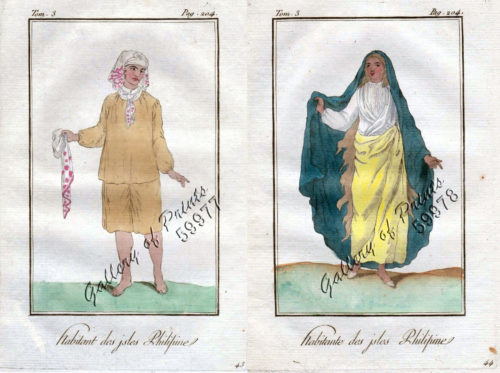
1) Habitant des Isles Philipine. 2) Femme des Isles Philipine [sic]
1 x
₱
18,700.00
Mapping the Philippine Seas
1 x
₱
5,900.00
Pont de Manille [Manila Bridge]
1 x
₱
49,500.00
Masbate I. - Port Kataingan
1 x
₱
4,400.00
Carte de la Mer de Chine… par M. Daussy,… capitaine Horsburgh… Sous le Ministère de M. Ducampe De Rosamel… au Dépôt-Général de la Marine en 1838.
1 x
₱
166,000.00
Dinagat I. - Port Gabo
1 x
₱
4,400.00
A New Voyage Round The World.
1 x
₱
1,980.00
Central Luzon. inset: Manila and Vicinity
1 x
₱
4,400.00
Cebu pl. 22 (Isla de Cebu, with inset - Isla de Mactan)
1 x
₱
7,700.00
China's Treasure [A Section from "The National Geographic Magazine, vol.XXIII, no. 10"]
1 x
₱
4,400.00
[Zig-zag emperor silkmoth, Gonimbrasia tyrrhea (African peacock moth, Phalaena tyrrhea)]
1 x
₱
4,400.00
Les Isles Philippines Molucques et de la Sonde…
1 x
₱
49,500.00
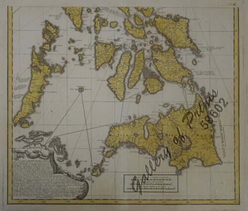
Carte des Isles Philippines, Celebes et Moluques [Kaart van de Filippynse, Celebes, en Molukse-Eilanden]
1 x
₱
13,200.00
Oryza Sativa. - Linn. - Blanco. - Miq. var. Binambang. - Blanco. var. Glutinosa - Blanco. var. Quinanda. - Blanco [Local Name: Rice]
1 x
₱
39,600.00
Philippine Islands Mindanao I. - South East Coast Pujaga Bay
1 x
₱
4,400.00
Charte von Ostindien diesseits und jenseits des Ganges [Map of East Indies both Sides of the Ganges]
1 x
₱
39,600.00
The Philippine Islands (Around the World Program)
1 x
₱
4,400.00
Itinéraire de l'ascension de l'Apó;… {Itinerary of the Mount Apo Conquest]
1 x
₱
6,600.00
The Philipine Isles
1 x
₱
88,000.00
Philippine Islands. Sibuyan Sea to San Bernardino Strait. From the United States Government Charts to 1934.
1 x
₱
11,000.00
The United States of America Including all its Newly Acquired Territory
1 x
₱
46,200.00
Philippine Islands. Western Part of Mindanao Sea with Bohol Strait and Part of Tañon Strait. From the United States Government Charts to 1937.
1 x
₱
13,200.00
East India Archipelago [Eastern Passages to China and Japan][Chart No.5] London, Published by James Imray and Son, 89 & 89a Minories, 1898
1 x
₱
36,000.00
East India Archipelago (Western Route to China. Chart No.6) London, Published by James Imray and Son, 89 & 102 Minories, 1872
1 x
₱
99,000.00
Philippine Islands. Luzon Island. North of Latitude 16° 20' North. From the United States Cost Survey Charts to 1925.
1 x
₱
11,000.00
Manille (pl.112)
1 x
₱
5,500.00
Plumiera Alba. - Blanco. - Plumeria Acutifolia. - Poir. - DC. [English: White Frangipani] [Local Name: White Kalachuchi]
1 x
₱
39,600.00
View Cart
Checkout
Home
About Us
Publications
Shop Online
Framing Services
Exhibits
Picture Hanging System
Contact Us
View cart
“Plumiera Alba. – Blanco. – Plumeria Acutifolia. – Poir. – DC. [English: White Frangipani] [Local Name: White Kalachuchi]” has been added to your cart.
Sort by
Popularity
Sort by
Default Order
Sort by
Name
Sort by
Price
Sort by
Date
Sort by
Popularity
Show
30 Products
Show
30 Products
Show
60 Products
Show
90 Products
Morinda Jasminoides [Sweet Morinda] [Jasmine Morinda]
₱
6,600.00
Add to cart
Details
Environs of Manila
₱
11,000.00
Add to cart
Details
Mapping the World: Maps and Their History
₱
5,500.00
Add to cart
Details
Atlas of Military History. An Illustrated Global Survey of ...
₱
4,400.00
Add to cart
Details
Yo vi la caida de Filipinas [I Saw The Fall of the Philippi...
₱
5,500.00
Add to cart
Details
The Sea Chart: The Illustrated History of Nautical Maps and ...
₱
3,500.00
Add to cart
Details
The Philippines. History, Geography, Customs, Agriculture, I...
₱
900.00
Add to cart
Details
El Sitio de Manila (1898) Memorias de un voluntario
₱
49,500.00
Add to cart
Details
The Inhabitants of the Philippines
₱
13,200.00
Add to cart
Details
Historia de la Provincia de Philipinas de la Compañia de Je...
₱
550,000.00
Add to cart
Details
A New Map of the East Indies, Taken from Mr. de Fer’s ...
₱
49,500.00
Add to cart
Details
Plan De La Baie De Bongo.
₱
6,600.00
Add to cart
Details
Plan de La Baie de Manille
₱
39,600.00
Add to cart
Details
Insulae Philippinae
₱
220,000.00
Add to cart
Details
Historia General de Philipinas : Conquistas Espirituales y T...
Details
Mapa de Filipinas, Joló y norte de Borneo
₱
7,700.00
Add to cart
Details
Expedición a Joló, 1876: Bocetos del Cronista del Diario d...
₱
4,500.00
Add to cart
Details
Carte des Iles Philippines Pour servirà l’intelligenc...
₱
980,000.00
Add to cart
Details
[Carte Reduite] Carte Réduite des Isles Philippines Pour Se...
₱
425,000.00
Add to cart
Details
[Carte Reduite] Carte Réduite des Isles Philippines Pour Se...
₱
425,000.00
Add to cart
Details
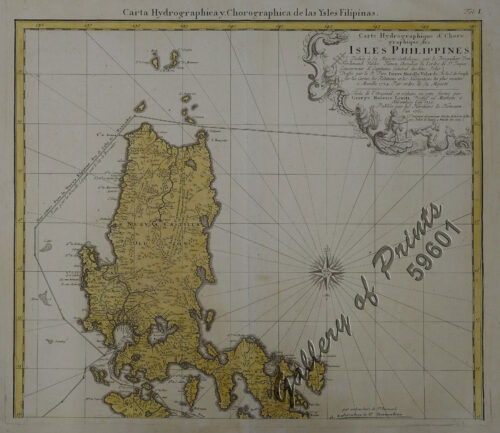
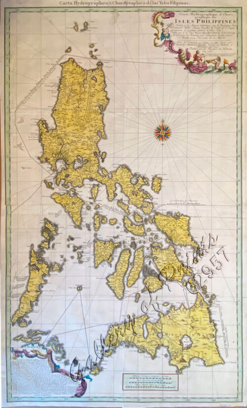
Carte Hydrographique & Chorographique des Isles Philippi...
₱
375,000.00
Add to cart
Details
Carte Hydrographique & Chorographique des Isles Philippi...
₱
375,000.00
Add to cart
Details
Carte du Canal des Isles Philippines par lequel passe le Gal...
₱
33,000.00
Add to cart
Details
Indie Orientale [Indochina] [China, Korea, Philippines] [Jap...
₱
790,000.00
Add to cart
Details
Cartografía Marítima Española En torno a varios de los p...
₱
4,000.00
Add to cart
Details
Environs of Manila
₱
11,000.00
Add to cart
Details
Bibliography of the Philippine Islands. Printed and Manuscri...
₱
4,400.00
Add to cart
Details
The Philippine Islands
₱
7,700.00
Add to cart
Details
Tahiti Girl Gathering Oranges.
₱
2,200.00
Add to cart
Details
A Boat Girl at Canton
₱
2,200.00
Add to cart
Details
Previous
1
2
3
…
13
14
15
16
17
18
19
…
54
55
56
Next
Shopping Cart
Plumiera Alba. - Blanco. - Plumeria Acutifolia. - Poir. - DC. [English: White Frangipani] [Local Name: White Kalachuchi]
1
Manille (pl.112)
1
Philippine Islands. Luzon Island. North of Latitude 16° 20' North. From the United States Cost Survey Charts to 1925.
1
East India Archipelago (Western Route to China. Chart No.6) London, Published by James Imray and Son, 89 & 102 Minories, 1872
1
East India Archipelago [Eastern Passages to China and Japan][Chart No.5] London, Published by James Imray and Son, 89 & 89a Minories, 1898
1
Philippine Islands. Western Part of Mindanao Sea with Bohol Strait and Part of Tañon Strait. From the United States Government Charts to 1937.
1
The United States of America Including all its Newly Acquired Territory
1
Philippine Islands. Sibuyan Sea to San Bernardino Strait. From the United States Government Charts to 1934.
1
The Philipine Isles
1
Itinéraire de l'ascension de l'Apó;… {Itinerary of the Mount Apo Conquest]
1
The Philippine Islands (Around the World Program)
1
Charte von Ostindien diesseits und jenseits des Ganges [Map of East Indies both Sides of the Ganges]
1
Philippine Islands Mindanao I. - South East Coast Pujaga Bay
1
Oryza Sativa. - Linn. - Blanco. - Miq. var. Binambang. - Blanco. var. Glutinosa - Blanco. var. Quinanda. - Blanco [Local Name: Rice]
1
Carte des Isles Philippines, Celebes et Moluques [Kaart van de Filippynse, Celebes, en Molukse-Eilanden]
1
Les Isles Philippines Molucques et de la Sonde…
1
[Zig-zag emperor silkmoth, Gonimbrasia tyrrhea (African peacock moth, Phalaena tyrrhea)]
1
China's Treasure [A Section from "The National Geographic Magazine, vol.XXIII, no. 10"]
1
Cebu pl. 22 (Isla de Cebu, with inset - Isla de Mactan)
1
Central Luzon. inset: Manila and Vicinity
1
A New Voyage Round The World.
1
Dinagat I. - Port Gabo
1
Carte de la Mer de Chine… par M. Daussy,… capitaine Horsburgh… Sous le Ministère de M. Ducampe De Rosamel… au Dépôt-Général de la Marine en 1838.
1
Masbate I. - Port Kataingan
1
Pont de Manille [Manila Bridge]
1
Mapping the Philippine Seas
-
Quantity
+
1) Habitant des Isles Philipine. 2) Femme des Isles Philipine [sic]
1
Cart
Checkout
Continue Shopping
27