Tel : +63(2)-7729-8168 | Mobile: +63 917 806 4291
|
Email: gallery@gop.com.ph
My Account
Remember Me
Register
5 Item(s)
-
₱
1,819,700.00
The Trouble in the Philippines: American Troops Entering San Fernando
1 x
₱
7,700.00
Sheet No. 3. Road Map from Lupao to S. Manuel plotted during Advance of Gen. Young's Brigade of 1st Div. 8th A. C. Maj. Gen. H. W. Lawton U. S. V. Commanding. Prepared under direction of John C. Oakes. 1st Lieut Corps of Engineers Division Engineer.
1 x
₱
6,600.00
Exacta & accurata delineatio cum orarum maritimarum tum etjam locorum terrestrium quae in Regionibus China, Cauchinchina, Camboja sive Champa, Syao, Malacca, Arracan & Pegu… Waarachtige uitworpinghe ofte afbeeldinge van alle die custen ende landen van China, … [Accurate & Detailed Drawing with Borders Maritime and even Terrestrial Places Located in the Regions of China….]
1 x
₱
999,000.00
A Chart of the China Sea, and Philippine Islands, with the Archipelagos of Felicia and Sooloo, shewing… …Canton and Balambangan,… composed from an original drawing, communicated by Capt. Robert Carr. and compared with the map of Pedro Murillo de Velarde, engraved at Manilla in 1734…. insets: 1) The Ports of Ylocos, on the West Coast of Luzon. 2) The Bay of Subic, on the West Coast of Luzon.
1 x
₱
780,000.00
1) Carte des Isles Philippines (1e feuille); 2) Carte des Isles Philippines (2e feuille)
1 x
₱
26,400.00
View Cart
Checkout
Home
About Us
Publications
Shop Online
Framing Services
Exhibits
Picture Hanging System
Contact Us
Sort by
Date
Sort by
Default Order
Sort by
Name
Sort by
Price
Sort by
Date
Sort by
Popularity
Show
30 Products
Show
30 Products
Show
60 Products
Show
90 Products
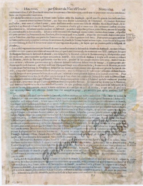
Ladmiral surmonte s’en allant au fond a nostre veúe
₱
49,600.00
Add to cart
Details
1. D. Francisco Lopez Arteaga. 2. La vida en Las Islas Filip...
₱
4,400.00
Add to cart
Details
1.) Amerikanische Soldaten feuern auf im Hinterhalt liegende...
₱
6,600.00
Add to cart
Details
Shopping Cart
1) Carte des Isles Philippines (1e feuille); 2) Carte des Isles Philippines (2e feuille)
1
A Chart of the China Sea, and Philippine Islands, with the Archipelagos of Felicia and Sooloo, shewing… …Canton and Balambangan,… composed from an original drawing, communicated by Capt. Robert Carr. and compared with the map of Pedro Murillo de Velarde, engraved at Manilla in 1734…. insets: 1) The Ports of Ylocos, on the West Coast of Luzon. 2) The Bay of Subic, on the West Coast of Luzon.
1
Exacta & accurata delineatio cum orarum maritimarum tum etjam locorum terrestrium quae in Regionibus China, Cauchinchina, Camboja sive Champa, Syao, Malacca, Arracan & Pegu… Waarachtige uitworpinghe ofte afbeeldinge van alle die custen ende landen van China, … [Accurate & Detailed Drawing with Borders Maritime and even Terrestrial Places Located in the Regions of China….]
1
Sheet No. 3. Road Map from Lupao to S. Manuel plotted during Advance of Gen. Young's Brigade of 1st Div. 8th A. C. Maj. Gen. H. W. Lawton U. S. V. Commanding. Prepared under direction of John C. Oakes. 1st Lieut Corps of Engineers Division Engineer.
1
The Trouble in the Philippines: American Troops Entering San Fernando
1
Cart
Checkout
Continue Shopping
5